“At the end of a period of five years professional employment by Durham County Council in the planning control of opencast coal mining in the Upper Gaunless Valley, I wanted to make some sense of the railways and tramways which I could see had once traversed the area. I could not easily find a written account of these railways and so I researched the subject myself. My main aim has been to obtain a geographical picture of the evolution of the railway system using Ordnance Survey maps. Other sources which I have used are listed in the bibliography. The paper has been written primarily for my own satisfaction but I hope that it may be of interest and use to others.”
Jon Hale August 1986
9 March 1990, Jon Hale provided me with a copy of his research and I have the pleasure in posting it here on the Evenwood, Ramshaw and District History Society website. It is a valuable addition to our knowledge of our industrial heritage. Jon did this work from a railway perspective, before the worldwide web was made available to the public and before the Durham Mining Museum was active therefore some details concerning coal companies may not be 100% correct. That said, this is the whole point of research, we can put something on the table, others can contribute and hopefully, in time, we can get to the bottom of things. We are indebted to Jon’s fine work. Some of the appendices and maps are not of the best quality but that is due to the inadequacies of our copying facilities. I have added some photos to compliment this work, many, courtesy of our friends at the Gaunless Valley Local History Trust.
Kevin Richardson 14 October 2023
CONTENTS
- Introduction
- The Mineral Resources in the Upper Gaunless Valley
- Coal mining in the Upper Gaunless Valley – a brief history
- The Stockton & Darlington Railway in south west Durham
- The Upper Gaunless Valley in the Early 1860s
- The Butterknowle Colliery Co system
- The Woodland Collieries Co system
- The Ramshaw Coal Co system
- Other Railways
Bibliography
Map 1. The Stockton & Darlington Railway in 1863
Map 2. The Upper Gaunless Valley in the early 1860s
Map 3. Mining and railway development
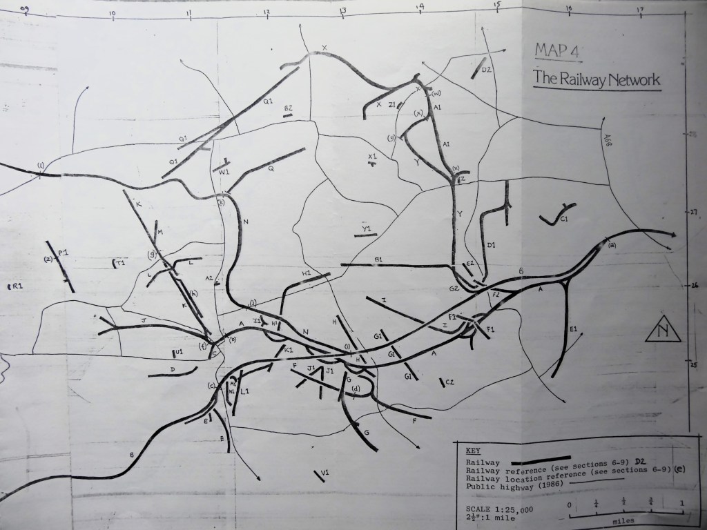
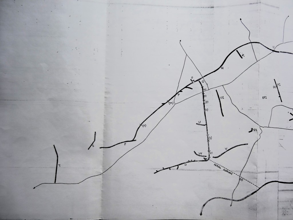
Map 4. The Railway Network
Table 1. Named coal seams which outcrop in the Upper Gaunless Valley
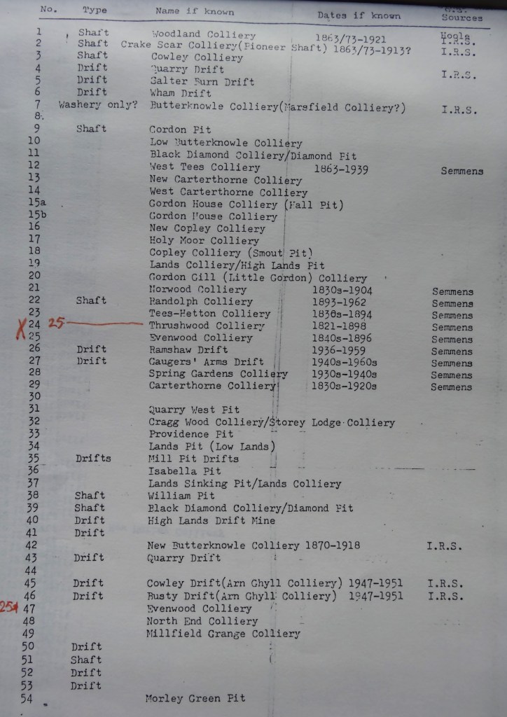
Table 2. Collieries in the Upper Gaunless Valley
- INTRODUCTION
In the west of the Durham coalfield the coal bearing rocks of the Coal Measures run out against the underlying older rocks of the Millstone Grit which form the Pennines. In the south west of the coalfield faulting has resulted in the Coal Measures extending further west than elsewhere in County Durham, to the extent that they underlie the Pennines moorland. This distinct westward “finger” of the coalfield lies principally within the valley of the River Gaunless to the west of the town of West Auckland. It is an area with a long history of coal mining, which was in the early years of the present century served by an extensive network of railways, but whose rural character today belies the scale of former industrial development.
The railway history of the Upper Gaunless is related principally to the history of coal mining in the area. The description here of the railway network is therefore preceded by a description of coal and other resources of the area, together with a brief summary of the mining history of the area. The area covered extends slightly beyond the watershed of the Upper Gaunless into areas drained in the north by the Linburn Back and Bedburn Beck (which flow into the River Wear) and in the south by the Langley Beck (which flows to the River Tees). The area is defined in the west by the boundary between the Coal Measures and the Millstone Grit, in the east by the present day A68 “Darlington Road” (which was, before the opening of the Stockton and Darlington Railway in 1825, the main route for the export of coal from the Upper Gaunless Valley) and in the north and south by the extent of the former railway system.
Map 1 is intended as a location map. Maps 2, 3 and 4 have been traced from the 1: 25,000 (2½”: 1 mile) OS map. They are intended to show the locations of all coal mines and railways which are recorded by the Ordnance Survey, together with other relevant detail. The sources for the locations of collieries have been 25”, 6”, and 2½” scale OS maps and so the resulting maps, produced by unsophisticated methods, are not completely accurate. The railways are diagrammatic and do not distinguish between lines of different gauge, neither do they show track layout.

The principle sources of historical information have been the 1st, 2nd, 3rd and 4th editions 25” and 6” scale OS maps. The text refers to the different editions by using their general publication dates – 1st edition 1863 (but see note below); 2nd edition 1897; 3rd edition 1919; 4th edition 1942. These must be regarded as approximate dates because the revisions or survey date of each map sheet may precede the general publication date by several years, and in some cases revisions may have been made after the initial publication date. The general publication dates of the 1st edition is 1857 but section 5 describes why the 1st edition is regarded for the purposes of this paper as illustrating the situation in 1863.
- 2. THE MINERAL RESOURCES OF THE UPPER GAUNLESS VALLEY
Coal
The Durham Coal Measures dip generally towards the east. The lowest seams therefore outcrop on the surface in the west of the county. Within the Upper Gaunless Valley, 12 named seams outcrop and they are listed in Table 1. In any particular locality the occurrence of seams and the distribution of their outcrops is affected by faulting and other geological features and may appear haphazard. The range of thickness for each seam within the area, as recorded by the Institute of Geological Sciences, is shown in Table 1, together with the seam intervals in the vicinity of Butterknowle. At least 6 further unnamed seams outcrop within the area – some are as thick as the named seams but most are recorded by the IGS as “thin”.
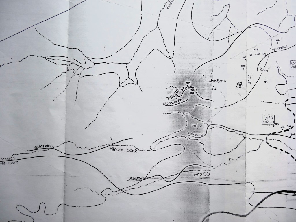
The seam which outcrops most extensively in the area, and which has been mined to the greatest extent, is the Brockwell seam. In simple terms there are 7 localities in which the seam outcrops, all of which have been the centres of mining and railway development. On the northern ridgeline of the valley the seam outcrops on both sides of the ridge about 30’ below the ridge top. For most of the length of the ridge (ie. Between Woodland and Windmill) there is no overlying seam and this encouraged early mining here by bell pit. The seam outcrops on both sides of the ridge which runs west from Butterknowle to Woodland. The coal measures are faulted in this area – in places the Brockwell seam lies at considerable depth. All other seams above the Brockwell apart from the Durham Low Main also outcrop and have been mined in this area. These first two areas come together in the vicinity of Woodland. The Brockwell outcrops in a small area to the east of Butterknowle between High Wham and High Lands, where it has been raised in a block by faulting. It lies at a depth of up to about 25’ but both Brockwell and an unnamed seam of up to about 20’ have now been completely removed from this area by both underground and opencast mining. The Brockwell seam underlies Cockfield Fell where it lies beneath the Busty seam at a depth of 100’. The Brockwell outcrops to the west and south of the Fell and both seams have been extensively mined on the Fell for several centuries. The seam outcrops in the vicinity of Ramshaw on the lower valley side. All other seams overlie the Brockwell here and outcrop successively on the hillside above. The Brockwell seam outcrops in the valley of the Arn Gill, west of Copley, where the Busty seam also outcrops. The seam also outcrops to the west of Woodland in the valley of the Hindon Beck where the Busty and Tilley seams also outcrop.
Seams underlying the Brockwell outcrop mainly to the west of Woodland and to the north of Woodland in the valley of the Linburn Beck. They have not been mined to any extent because of their relative thinness. In the area lying between Softley and Coleburn Covert the Victoria seam is generally not present. Boreholes show the next seam down – the Marshall Green – to be at a depth of 100’ to 150’. Consequently, there has been little mining development in this area and railways traversed the area only in order to reach other areas.
TABLE 1. NAMED COAL SEAMS WHICH OUTCROP IN THE UPPER GAUNLESS VALLEY
| Present seam name and Seam interval | Seam thickness | Local or old Seam names |
| Durham Low Main | 30” – 63” | Seam not present west of High Toft Hill |
| Brass Thill | 18” – 55” | |
| 100’ | ||
| Hutton | 42” – 50” | |
| 25’ | ||
| Jubilee | 0” – 49” | |
| 75’ | ||
| Harvey Marine Band | Thin | |
| 50’ | ||
| Harvey | 7” – 77” | Engine |
| 80’ | ||
| Top Tilley | 0” – 17” | |
| Tilley | 2” – 30” | Constantine |
| Bottom Tilley | 0” – 23” | |
| 25’ | ||
| Top Busty | 20” – 45” | Ballarat |
| Busty | 38” – 96” | |
| Bottom Busty | 14” – 40” | Fivequarter, Sixquarter |
| 70’ | ||
| Brockwell | 39” – 98” | |
| 55’ | ||
| Victoria | 0” – 25” | |
| 60’ | ||
| Top Marshall Green | 0” – 23” | |
| Marshall Green | 18” – 23” | |
| Bottom Marshall Green | 2” – 67” | Cowley |
| 40’ | ||
| Ganister Clay | 2” – 34” | Kays Lea |
| 575’ | ||
| Base of Coal Measures |
Other minerals and mineral products
Clays and shales occur in conjunction with some coal seams and these have been mined for the manufacture of bricks and more recently for the manufacture of refractory products. Brickworks are known to have existed at Butterknowle, Low Lands and Haggerleases Station and there were probably many others. None remains today but opencast mines in the area continue to supply clays and shales to brickworks elsewhere in the county.
The principle rock type forming the coal measures is sandstone and this has been quarried in the area for use as building stone. The most extensive single quarrying operation in the area, however, has been the extraction of hard igneous rock of the Cleveland Dyke from Haggerleases, Cockfield and Cragg Wood Quarries on, and to the east of Cockfield Fell. The dyke is some 30 yards wide and Cockfield Quarry forms a trench 2/3rds of a mile long and some 30 yards deep across the Fell. Cragg Wood Quarry lay to the east but it is now almost completely infilled and restored to farmland. Haggerleases Quarry lies to the west. The quarries operated until the last war and supplied stone for use as railway ballast and roadstone.
Several of the coal seams in the area produce coal suitable for coke manufacture. Coke ovens are known to have existed at a number of collieries in the area, most recently at Randolph Colliery, Evenwood – the colliery and its railway closed in 1962 but the coke works remains operational until 1984 using coal supplied by opencast mines in west Durham.
Coal and associated clays and shales are the only minerals mined in the area today.
- 3. COAL MINING IN THE UPPER GAUNLESS VALLEY – A BRIEF HISTORY
In the late 14th Century, the Northumberland and Durham Coalfields began to develop a sea-borne coal export trade with London. Prior to this date, most coal mining in County Durham had taken place on a small and local scale, but as the export trade grew, considerable mining development took place in the areas closest to the Rivers Tyne and Wear which were navigable well inland. The earliest record of collieries in south west Durham date from the C14. These collieries would have been too far from the centres of sea-coal trade and so would have supplied local markets – in particular the towns of Darlington, Richmond, Barnard Castle and Bishop Auckland. C14 collieries are recorded in the Upper Gaunless Valley at Cockfield, Evenwood and Railey Fell. In the C15 the Bishop of Durham granted a lease for coal mining in the Evenwood area and mines are recorded from this time at Railey Fell, Caldhirst, Toft Hill, Copley and possibly Morley. Collieries are recorded in the area in the C17 at Softley, Grewburn, Cockfield, Carterthorne and Evenwood. By this time the collieries in north west Durham had constructed a complex network of wagonways to convey their coal to the Wear and the Tyne but the collieries in south west Durham continued to export by pack pony. In 1769 a canal was proposed between the Upper Gaunless Valley and the River Tees at Winston, in order to improve accessibility. The proposal was for the canal to follow the contour from Railey Fell via Copley to Keverstone Bank near Raby and for an inclined plane from this point to the River Tees some 3½ miles away. The scheme was not taken up and it was not until 1825 that communications were substantially improved when the Stockton and Darlington Railway opened between Phoenix Pit at Witton Park and Stockton on Tees. The railway ran through West Auckland which, for the next 5 years was the railhead for the Upper Gaunless Valley. The Haggerleases branch of the Stockton and Darlington Railway, from West Auckland to Butterknowle was opened in 1830.
- 4. THE STOCKTON AND DARLINGTON RAILWAY IN SOUTH WEST DURHAM
The Stockton and Darlington’s 1825 main line followed the route – Stockton – Dinsdale – North Road, Darlington – Shildon – Brusselton Incline – West Auckland – Etherley Incline – Phoenix Pit. In 1842, the rope-worked Etherley Inclines were superseded by the construction of the Stockton and Darlington Railway’s line through Shildon Tunnel to Crook via Bishop Auckland and Witton Park. The Brusselton Inclines were superseded in 1856 when S&DR built a line from the north end of Shildon Tunnel following the Gaunless Valley to West Auckland. Locomotives had been used on the S&DR from the outset although they did not work west of Shildon until the bypassing of the Brusselton Inclines. Until 1856, therefore, the Haggerleases line was worked by horses. In 1858, a passenger service was introduced on the Haggerleases branch, running as far as Lands. This service was withdrawn in 1872 because alternative services were by then available on the West Auckland – Barnard Castle line which had stations at Ramshaw and Cockfield. By the 1850s, the S&DR had become a major railway company in south and west Durham. Its 1842 Shildon – Crook line had been extended in 1845 to Tow Law and Burnhill (Waskerley) where it joined the Stanhope and Tyne Railway, which gave the S&DR access to the growing ironworks at Consett. The Consett – Stanhope section of the Stanhope and Tyne Railway was taken over by the S&DR in 1858. In the mid-1850s consideration was being given to a trans-Pennine railway west from the south west Durham coalfield. A S&DR controlled company, the South Durham and Lancashire Union Railway, obtained Parliamentary approval in 1857 for a line running from Spring Gardens Junction on the Haggerleases branch one mile out of West Auckland to Tebay on the Lancaster and Carlisle Railway. The line passed through Barnard Castle and Kirkby Stephen and crossed the Pennines at Stainmore. The line was opened I 1863, the year in which the S&DR was amalgamated into the North Eastern Railway. The SD&LUR line carried heavy mineral traffic throughout its life. It close in 1962. The last section of the Haggerleases branch – from Randolph Colliery to West Auckland – closed in 1963.
The SD&LUR line provided the most substantial railway remains in the Upper Gaunless Valley today. It crossed the River Gaunless by Lands Viaduct, formed of lattice girders on double circular brick piers. The girders were removed when the line closed and only one of the impressive piers remains standing; the remains are nevertheless impressive.

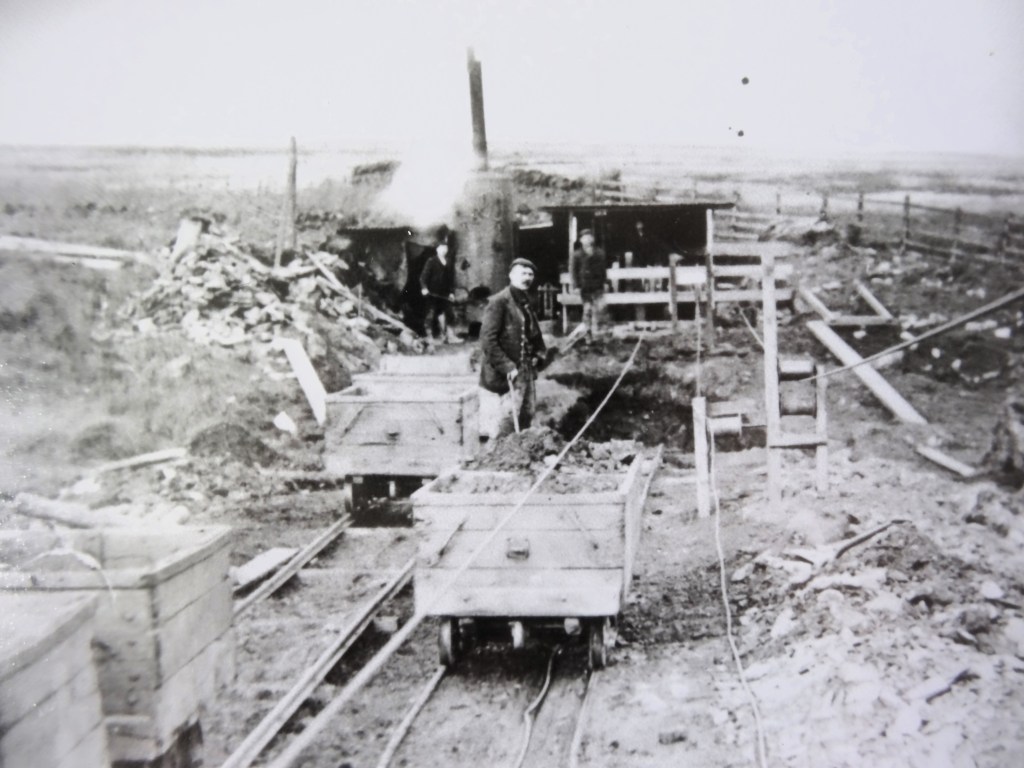
Above: Gordon House Colliery screens, the Haggerleases branch line and the viaduct carrying the SD&LUR called either the Gaunless, Cockfield or Lands Viaduct.
- 5. THE UPPER GAUNLESS VALLEY IN THE EARLY 1860s
The 1:10,560 (6”:1 mile) version of Sheet 41 in the Durham County Series of the first edition of the Ordnance Survey was published in 1857. It appears that this edition was amended after this date because it shows the SD&LUR line (which was not opened until 1863) as an operational railway. It may be, therefore, that other amendments were made to the map after 1857. For the purposes of this paper the first edition OS map is regarded as a record of mining and railway development in the Upper Gaunless Valley in the early 1860s: this is 30 years after the opening of the Haggerleases branch and the time of the opening of the SD&LUR line.
Coal mining
The extent of mining development, as recorded by the OS is shown on Map 2.
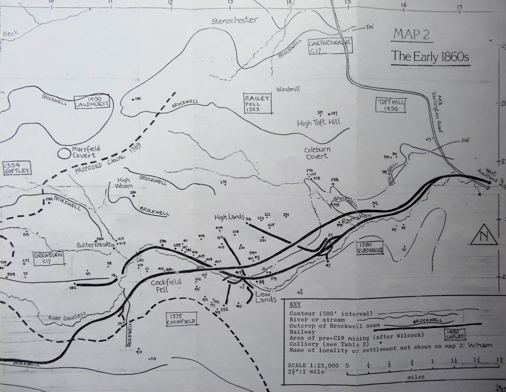
Railways
The OS map shows the following railways as operational in the early 1860s.
Haggerleases branch (A)
After the opening of the SD&LUR line this ran from Spring Gardens Junction (a) to Haggerleases terminus (b). There were sidings at Norwood Colliery (21), Evenwood Colliery (47) and Low Lands.
The SD&LUR line (B)
This followed the former Haggerleases branch as far as Spring Gardens Junction and then ran southwest to the watershed south of Copley. The only sidings were at Cockfield Station (c).
A westward extension from the Haggerleases Terminus (C)
This was a standard gauge continuation of the Haggerleases branch along the north bank of the Gaunless. It crossed the Grewburn Beck at its confluence with the Gaunless and terminated in the locality known as The Slack, adjacent to the present day Stag’s Head Inn. By 1897, the line no longer ran to The Slack but curved northwards after crossing the Grewburn Beck.
Copley Colliery (Smout Pit) tramway (D)
The tramway, Copley Colliery (Smout Pit) (18) and the drift (282) had all closed by 1897.
Cockfield Station tramway (E)
By 1897, the tramway had been lifted and its colliery (291) closed. Additional sidings off the SD&LUR line had, however, been built by this date, together with coke ovens leading to New Copley Colliery (16) which was still working in 1919, although the coke ovens were by then out of use. The colliery and tramway had closed by 1942.

Above: Map to show New Copley Colliery & Coke Ovens
Tramways leading to sidings at Low Lands
The eastern tramway (F) served Cockfield Quarry, then only 400 yards long (d). Cragg Wood Quarry was at this time also 400 yards in length but its tramway had not been started – the tramway is shown on the 1897 and 1919 maps but it had been lifted by 1942. Cockfield Quarry tramway was still in existence in 1942 – the IRS states that it closed shortly after the war when the quarry closed. Two locomotives recorded by the IRS as having worked on the system are, “W. Summerson” and “Roseberry” both 0-4-0 saddle tanks built in 1892, the gauge being 2’ 3½”. The other tramway (G) ran from Dean Colliery (292). The colliery had closed by 1897 but the tramway had by this date been extended to Gordon House Colliery (15A). The tramway was further extended between 1897 and 1919 when a new Gordon House Colliery (15B) was opened and the earlier one closed. By this time, the line crossed the extending Cockfield Quarry by bridge. The IRS states that the line was laid to standard gauge. The second Gordon House Colliery closed about 1930.
Lands Colliery tramway (H)
This line was severed by the construction of the SD&LUR line and was not rebuilt.
The Isabella Railway (I)
The line is shown by this name on the OS map. It connected Isabella Pit (36) to Norwood Colliery (21). The Isabella Railway was also severed by the SD&LUR line and not rebuilt.
Over the next 80 years, three principal railway systems developed and subsequently declined in the Upper Gaunless Valley – the Butterknowle Colliery Co. system, the Woodland Railway and associated tramways and the Ramshaw Coal Co. system of tramways.
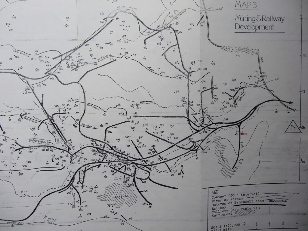

- 6. BUTTERKNOWLE COLLIERY CO. SYSTEM
The full extent of this system appears to have been built between 1863 and 1897. The continuation of the Haggerleases branch divided at the east end of Butterknowle village into 2 lines. The western line (J) ran to Quarry Drift (4) and Quarry West Pit (31) along the bank of the Grewburn Beck. The northern line (K) ran to South Side along the bank of the Crow Howle Beck and thence to Marsfield Covert. The system was laid down to standard gauge and the IRS record 3 locomotives which worked on it; “Copley” of unknown date, “Butterknowle” built 1871 and “Shotley” built 1873, all of them saddle tanks and the second and third locomotives known to have been bought new. Butterknowle Colliery Co. was registered in 1885. At an unknown date the company became New Butterknowle Colliery Co. Ltd. The system is described here by reference to the collieries which it served.
Quarry Drift and Quarry West Pit
These lay at the end of the western line. Quarry Drift was working in 1897 and 1919 but had closed by 1942. Quarry West Pit was working in 1897 but had closed by 1919. Between 1897 and 1919, the line serving these mines was re-laid as a tramway – the standard gauge terminated at interchange sidings just north of the bridge over Grewburn Beck near its confluence with the Gaunless (f). The western line is named “Butterknowle Colliery Railway” in 1897 and “Quarry Drift Tramway” in 1919.
Unnamed drifts and shafts between the western line and Grewburn Beck
The IRS refers to this location (ie to the immediate south of Butterknowle village (s)) as Marsfield Colliery and Coke Ovens but these are more likely to be the colliery and coke ovens lying adjacent to the northern line of the system (7). The OS maps show that there was no colliery or tramway of this nature described by the IRS in the location they refer to.
Butterknowle Colliery (280)
This is shown on the 1st edition OS map as lying within the eastern end of the present Butterknowle village. It is not shown on subsequent editions of the OS and may therefore be assumed to have closed between 1863 and 1897.
Black Diamond Colliery (11)
This is shown on the 1st edition OS map as lying inside the confluence of the Grewburn Beck and Crow Howle Beck. On the 2nd edition this s shown as, “Diamond Pit” but the colliery had closed b 1919. The 1897 OS map shows as, “Black Diamond Colliery” (39) a colliery lying immediately south of the confluence of the 2 becks. This mine had also closed by 1919.
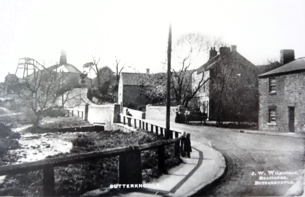
Above: Diamond Pit, Butterknowle

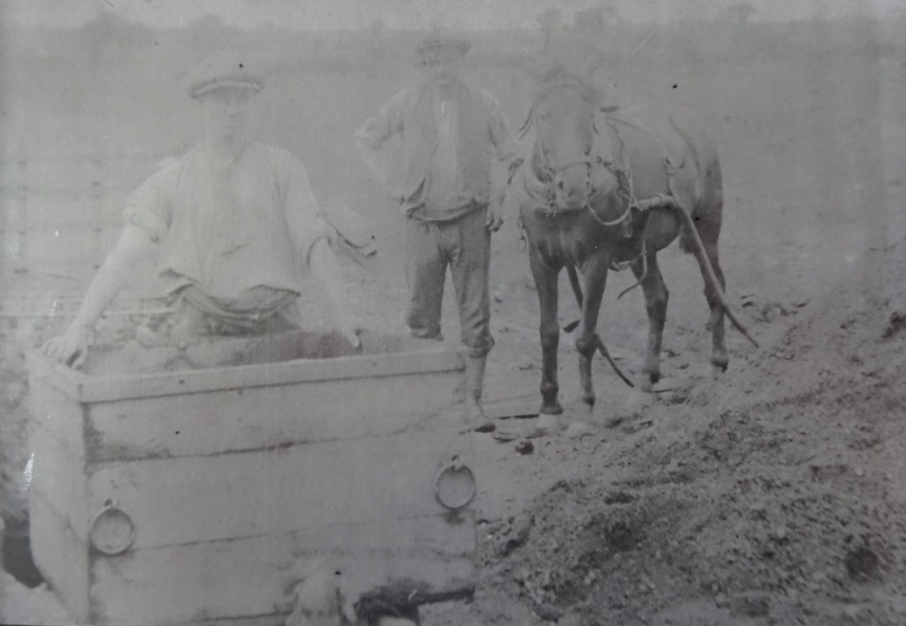
Above: Quarry Drift miners
New Butterknowle Colliery (42)
This colliery was working in 1897 but had closed by 1919. The IRS states that the colliery was open by 1870 and that it closed at the time of the First World War.
Gordon Pit (9)
This was working in 1897 but it too had closed by 1919.
Butterknowle Colliery (Marsfield Colliery) (7)
The 1897 OS map shows a colliery called Butterknowle Colliery lying at what appears to have been the central point of the northern part of the system. The colliery lies about 1000 yards from a house called Marsfield and is more likely to be the Marsfield Colliery referred to by the IRS than the location described above. The IRS state that Marsfield Colliery opened in the latter half of the 19th Century and was closed in 1910 together with its coke ovens.
To the northwest of the colliery the 1897 OS map shows a disused railway which formerly ran to a drift mine at Marsfield covert (216). In the vicinity of Marsfield Colliery this railway appears before 1897 to have run to the colliery which lay at a higher level than the coke ovens and the railway running from Butterknowle village. In 1897 2 tramways (L) converged on Marsfield Colliery from Wham Drift (6) and Salter Burn Drift (5) and these tramways appear from their alignment in the vicinity of the colliery to have superseded the Marsfield covert railway when it closed. The Marsfield Covert line was steeply graded and may not have been worked by locomotives. It crossed the South Side road on a viaduct. The tramways were fairly level and may have been worked by locomotives (see below).
Above: Salter Burn Drift
Marsfield Colliery appears to have been only a central processing point for coal mined elsewhere – no drifts or shafts are recorded at the site and the IRS refers to Marsfield Washery. It appears from the colliery layout shown on the 1897 OS map that washed and screened coal was discharged from the colliery through a gantry into wagons standing on the lower level standard gauge sidings. Lines ran from here to the coke ovens (h). Standard gauge lines ran between the coke ovens and were connected to the rest of the system. The IRS states that Marsfield Colliery and Coke Ovens had 3’0” gauge system running between the washery and the coke ovens. It appears from the 1897 OS map, however, that the coke ovens lines were all standard gauge and that the narrow gauge system described by the IRS is that running between the drifts and the washery. The IRS records one 3’0” gauge locomotive – “Firefly” built in 1873 and delivered new. It was an 0-4-0 saddle tank and was sold by the company in 1910.
An additional section of line is the former tramway shown on the 1897 OS map running between the Marsfield Covert line and Marsfield House (M). There are no shafts or drifts recorded in the vicinity of this line and so it may have been either an abandoned extension towards Coldhirst or a line built to carry goods to and from Marsfield House.
All collieries and associated railways, tramways and coke ovens on the northern section of the system had closed by 1919. The IRS state that “Butterknowle” was offered for sale in 1910 but the fate of none of the 3 standard gauge locomotives is known. 1910 could have been the date when the western line was re-laid to narrow gauge, although probably not to 3’0” gauge, in view of the sale of, “Firefly”. The IRS refers to Copley and Shotley Collieries which were also owned by the company, their locations being unknown. Copley Colliery could have been Smout Pit (18) or any of the mines in the vicinity of Copley.
The principle remains of the system are the trackbeds of the lines, the heaps at Quarry Drift, Quarry West Pit and Marsfield Colliery and Marsfield Colliery coke works.
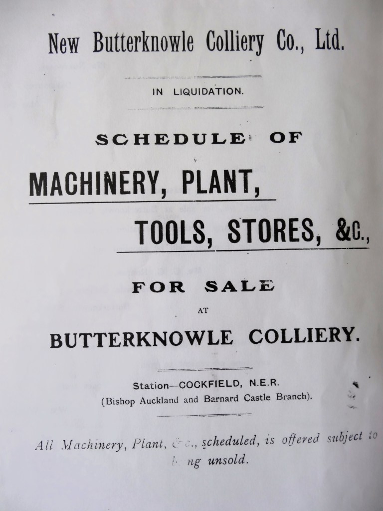
Above: New Butterknowle Coal Co. Ltd. – Liquidation Sale Catalogue front page.
- 7. THE WOODLAND COLLIERY CO. SYSTEM
The company appears to have owned Woodland Railway (N) and the 4 collieries directly served by it: Morley Colliery, Crane Row Colliery, Crake Scar Colliery and Woodland Colliery. Two separate systems extended south and west of Woodland Colliery – the Woodland Tramway (O) and the Woolly Hills Tramway (P) – and these may also have been owned by the company.

The opening date of the Woodland Railway is stated by the IRS as about 1863 (ie at the time of the opening of the SD&LUR line with which Woodland Railway had a junction) and by Hoole as 1873. The IRS states that he company was registered in 1880 and that in 1914 the company became a subsidiary of Cargo Fleet Iron Co Ltd. The Woodland Railway closed in 1921 and Hoole states that it was dismantled 2 years later. The IRS records 4 locomotives which worked on the line and a further 3 locomotives which are recorded as having worked at Woodland Colliery, all 7 being standard gauge. The line was originally worked for the company by the North Eastern Railway. The IRS states that the colliery company took over the operation in 1885 but Hoole states that this did not occur until 1911, on the basis that in this year the colliery company bought a locomotive from the NER. This purchase is recorded by the IRS but it also records locomotive purchases by the company in 1885, 1886, and 1891, indicating that the IRS date is more likely that Hoole’s.
The Woodland Railway consisted of a single line which ran from Woodland Junction (i) for 5 miles to Woodland and climbed 550 feet. There are no engineering works of any significance on the line. It leaves SD&LUR line at the east end of Lands Viaduct and climbs quite steeply across the northern side of the Gaunless Valley. After crossing Lands Road (j) it curves northwards to gain the western side of a spur of higher land which separates the tributary valleys of the Crow Howle Beck (occupied by the Butterknowle Colliery Co system) and the Day Gill Beck/Gordon Beck (occupied further downstream by the Ramshaw Coal Co tramway system) before curving westwards again above the head of Crow Howle Beck on the northern ridgeline of the Gaunless Valley. Although several coal seams outcrop on the hillside below and above Lands Road and the railway crosses the area of shallow Brockwell coal in the vicinity of Wham, there appears to have been no particular mining development in this area associated with the Woodland Railway. The only possibility is Wham Colliery (129 & 130) which was working in 1863 and remained in operation in 1919. The line appears from OS maps, to have crossed Lands Road on a bridge, the line being on an embankment at this point. There is no trace of the bridge or embankment today although “Railway House” remains at the crossing point.
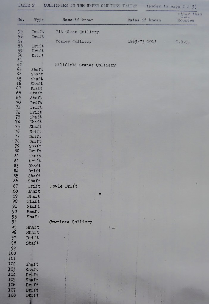
At the point where the line is curving westwards onto the ridge top, and just before it crosses the Wham road on the level (k) a tramway (Q) met the railway, terminating at what may have been a yard or coal depot adjacent to both railway and road. The tramway ran on or near level alignment to Morley Colliery (57), which is stated by the IRS as having been owned by Woodland Collieries Co. The colliery may be assumed to have opened at about the same time as the railway and the IRS state that it had closed by 1913. Although the tramway runs towards the Brockwell outcrop, Morley Colliery lay just outside the outcrop and was a shaft working seams below the Brockwell. Nearby boreholes on the IGS map show the Victoria seam not present here, the Marshall Green seam as 16” – 20” thick at a depth of 128’ – 141’ and the Ganister Clay 8” thick at 191’ – not a good mining prospect when the nearby Brockwell is 66” thick at 20’. The Brockwell would probably have been heavily worked in this area by the time the Woodland Railway was built.
Crane Row Colliery (41) lay to the south of Crane Row Lane, east of the point where the railway crossed the lane on a bridge (1). This colliery is also likely to have opened at the same time as the railway and the IRS state that it, too, was closed by 1913.
Crake Scar Colliery (2) and Woodland Colliery (1) appear to have been the principal collieries on the line. The IRS states that Crake Scar Colliery closed soon after 1913 but the Woodland Colliery remained open until 1921 when the railway closed. Crake Scar Colliery comprised both a shaft adjacent to the railway (working the Brockwell 72” at 26’ and the Top Marshall Green 10” at 145’) and other drifts and shafts which were connected to it by a tramway (R). The sidings at Crake Scar were more extensive than those at Woodland Colliery and this may therefore have been the point where trains were made up prior to travelling down the line.
Woodland Colliery appears to have comprised 2 shafts adjacent to the railway. The 1919 OS map shows what appear to be 2 loco sheds to the east of the pithead and there also appears to have been an elevated siding serving coal drops adjacent to the road which passed through the colliery. In 1897, 2 tramways converged at the colliery; Woolly Hills Tramway from the west and Woodland Tramway from the south. By 1919, the former had been closed and taken up although a new short tramway had been laid to a drift (112) to the northwest of the colliery. The Woodland Tramway was still in existence in 1919, although it may be assumed to have closed at the same time as Woodland Colliery and the railway.
Above: Believed to be Woodland Colliery coke ovens

Above: Woodland Cokemen
Woolly Hills Tramway ran for a distance of some 1¾ miles to the valley of Hindon Beck. Two winding houses are shown in 1897 at Pikestone Engine (m) and Hindon Engine (n) and so the section descending 200 feet from Pikestone Engine to Hindon Beck would have been rope worked. The Woodland Colliery – Pikestone Engine and the Hindon Beck sections are relatively level, however, and locomotives may have been used. The tramway served a number of mines along its route, all of which had closed by 1919.
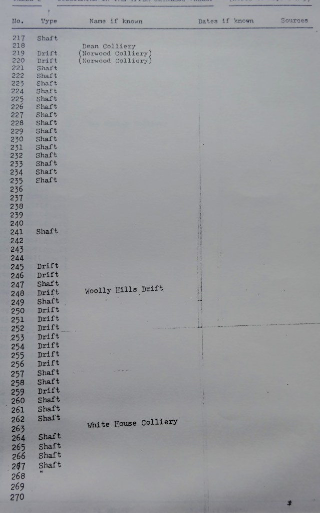
Two further mines were worked to the west of the Woolly Hills Tramway; the easternmost was working (245) in 1953 and was connected to a moorland road by a tramway (S) and the other (263) known as White House Colliery, was also connected to the nearest road by a tramway (T).
Above: White House Colliery
The Woodland Tramway ran for a distance of some 1¼ miles to the valley of the Arn Gill and thence ¾ mile along the valley of the Gill. The line descended 300 feet between Woodland and Arn Gill and would have been rope worked. The Arn Gill section is relatively level and may have been locomotive worked. The tramway passed through 4 tunnels between Woodland and Arn Gill (o; p; q & r) and there were 2 viaducts on this section (t; u). The tramway served a number of drifts in Arn Gill, together with Cowley Colliery (3) which lay at the end of a short branch (U). The colliery remained in operation after the tramway’s closure.
Two further mines were worked to the east of the Arn Gill tramway but were not directly served by it. One (76) had closed before 1897; the other (77) was still working I 1897 but had closed by 1919. Both mines appear to have been served by a line marked on the OS maps as a wagonway (V) which ran from the mines near Copley and which closed and lifted by 1897.
Two mines to the west of Woodland – Arn Gil section of the tramway were opened in 1947 by the National Coal Board – Cowley Drift (45) and Busty Drift (46) together formed Arnghyll Colliery. Two drifts were connected by a tramway ( W ) on which locomotives were used. The IRS states that the colliery was closed in 1951.
An aerial ropeway (v) is shown on the post war OS map but not on earlier editions, suggesting that it was built to carry coal from Arnghyll Colliery. It ran to a siding on the SD&LUR line.
There has been opencast mining and land reclamation over much of the route of the Woodland Railway and on the sites of its collieries. Woodland Junction remains and the trackbed can easily be traced immediately west of the junction and in the vicinity of the Wham road crossing where trackside fencing still exists. The route of the Woodland Tramway can be easily traced and engineering works remain.
8. THE RAMSHAW COAL CO. SYSTEM
The IRS states that little is known about the Ramshaw Coal Co. or which collieries it owned. It records that in 1937 it owned Ramshaw No.1 and Ramshaw No.2 Collieries and that a narrow gauge line conveyed coal from 2 drifts known as Carterthorne Colliery to screens at Ramshaw. The OS maps indicate that there were at various times tramways converging on Ramshaw from 3 directions. It is these tramway systems, together with the lines within Ramshaw which are described in this section.
High Lands – Ramshaw Tramway (B1)
This line is shown as disused on the 1897 OS map. It appears to have connected Lands Colliery (High Lands) (37) with West Tees Colliery (12) at Ramshaw. Part of the tramway alignment in the immediate vicinity of Ramshaw was later used to accommodate standard gauge sidings off the SD&LUR line (see below).
Carterthorne Collieries system
This originated as 2 separate tramway systems; one connecting coal mines in the Stonechester area (X) to New Carterthorne Colliery ( w ) (13) and the second system connecting mines in the High Toft Hill area (running as far north as points (x)) with Ramshaw.
The Stonechester system was built between 1897 and 1919. By 1919, New Carterthorne Colliery ( w ) had closed and its site was in use as a roadside depot.
The Ramshaw system was also built between 1897 and 1919. It comprised 2 unconnected tramway lines which ran adjacent to each other between Ramshaw and High Toft Hill. The eastern line terminated at High Toft Hill at 2 drifts (59 & 329) which comprised Carterthorne Colliery. The 1897 map shows a short tramway (Z) connecting Carterthorne Colliery (59) to the road; this tramway was superseded by the later line. The western line ran to West Carterthorne Colliery (14) and a coal depot (y) adjacent to the road at Windmill. The 2 tramway lines ran to separate sets of standard gauge sidings at Ramshaw (see below).
The completed system. The Stonechester and Ramshaw systems appear to have been connected between 1915 and 1921 by the construction of a line from New Carterthorne Colliery direct to Carterthorne Colliery with a spur to West Carterthorne Colliery. The line from West Carterthorne Colliery to the Windmill coal depot was closed at this time. (A1) The system is shown in this way on the 1947 1” edition of the OS map, which is stated to have been fully revised in 1921. The 1919 25” OS map was revised in 1915 and does not show the complete system. The connection can therefore be regarded as having been built between the dates stated above. The 1942 25” OS map (which was revised in 1939) shows the entire tramway system had closed by this date.
An earlier Carterthorne Colliery (29) lay t the east of New Carterthorne Colliery and was linked to mines to the south west by a tramway (D2).
The Martinfield system (D1)
In 1897 a tramway ran from a drift (510) the short distance to West Tees Colliery in Ramshaw. By 1919 this tramway had been extended northwards to connect a number of drifts. Martinfield Harvey Drift (487) lay at the centre of the system. The entire system had closed by 1942.
Ramshaw
The layout of standard gauge lines and tramways was complex. In the early 1860s the only lines were the low level Haggerleases branch and the high level SD&LUR line. There were no sidings or tramways at this time.
By 1897 a line (F2) had been built from the Haggerleases branch to West Tees Colliery which lay to the north of the SD&LUR line but at the lower level. The standard gauge line to the colliery ran under the SD&LUR line and did not connect with it. The High Lands – Ramshaw tramway had run to the southern side of West Tees Colliery (but had closed by1897) and the Martinfield tramway ran to the northern side of the colliery. A further tramway (E2) at this time ran between 2 drifts (395 & 539) but did not connect with any other surface lines.
By 1919 2 separate sets of standard gauge sidings (G2) had been built at the higher level branching off the SD&LUR line. These were interchange sidings for the Carterthorne Colliery tramway system and at their northern end they occupied part of the alignment of the former High Lands – Ramshaw tramway.
By 1942 only the Haggerleases branch, the SD&LUR line and the line serving West Tees Colliery (F2) remained.
9. OTHER RAILWAYS
Railways connected with the SD&LUR line or the Haggerleases branch
Randolph Colliery branch (E1)
This standard gauge line would have been built when the colliery was opened in 1893 (22).
Tramways at Norwood Drift (F1)
Norwood Colliery worked between the 1830s and 1904. The 1897 OS map shows tramways running to the northwest and southeast, each connecting a drift with the main colliery site. The south eastern tramway crossed both the Haggerleases branch and the River Gaunless. The tramways had been removed by 1919.
Tramways at Storey Lodge (Cragg Wood) Colliery (G1)
This colliery also had tramways running to drifts in the valley sides. The colliery is shown as working on the 1863 and 1897 OS maps nut it had closed by 1919.
High Lands – Low Butterknowle tramway (H1)
A tramway was built from sidings on the Haggerleases branch at Low Butterknowle to New Morley Colliery (126) between 1897 and 1919. The 1947 1” edition of the OS map (fully revised 1920) shows the tramway extended to High Lands. The tramway appears to have crossed Lands Road on the level. The line had been removed by 1942.
Low Butterknowle Colliery tramway (I1)
This short tramway connected the mine (10) with sidings on the Haggerleases branch. It had been removed and the colliery closed by 1942.
Other colliery tramways on Cockfield Fell (J1; K1; L1; M1; N1)
None of these lines existed in 1863 and all except Holy Moor Colliery tramway (N1) had closed by 1919. The eastern J1 line is shown as disused in 1897, having been severed by Cockfield Quarry. The western J1 line was operational in 1897 but it, too, had been severed by 1919. The short eastern K1 line is shown as disused on the 1897 map but the western line is operational. There is evidence on the OS maps that the alignment and extent of these lines on Cockfield Fell were subject to change.
Short surface extensions of underground mine tramways
The lines at the following collieries appear to fall into this category:
- Howle (R1)
- Cowclose (Copley) (S1)
- Potters Cross (T1)
- Butterknowle (U1)
- Burnthouses (V1)
- Hawthorn (W1)
- Pit Close (X1)
- Morley (B2)
- Morley Green Pit (Z1)
- Wham (A2)
- Day Gill Beck (Y1)
- Norwood (C2)
Longer Lines
The tramway system (C1) to the northeast of Ramshaw connected a number of mines with the nearest road. It appears
To have been of a similar style and probably of the same era as the Martinfield tramway system (D1). The easternmost mine on the system appears to have been named Ramshaw Drift (274) and may have been one of the Ramshaw Coal Company’s Ramshaw Collieries which are referred to by the IRS.
The tramway running from Cowclose Colliery, Woodland (94) (C1) appears to have reached its maximum extent between 1863 and 1897 when the section south of drift 97 is shown as disused. The line had further receded by 1919 and appears to have closed after this date.
The tramway at Softley (P1) is shown as operational only on the 1919 OS map. The OS map shows an Engine House at point (z).
The line from Coldhirst to Stonechester (Q1) is not shown on the 1863 OS map but is described on the 1897 edition as an old wagon way. It follows the outcrop of the Brockwell seam. The line appears to have been closed before the construction of the Stonechester – New Carterthorne Colliery tramway (X).
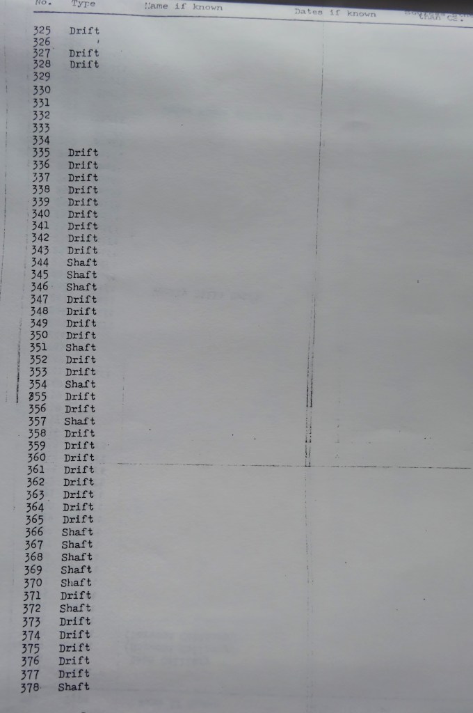
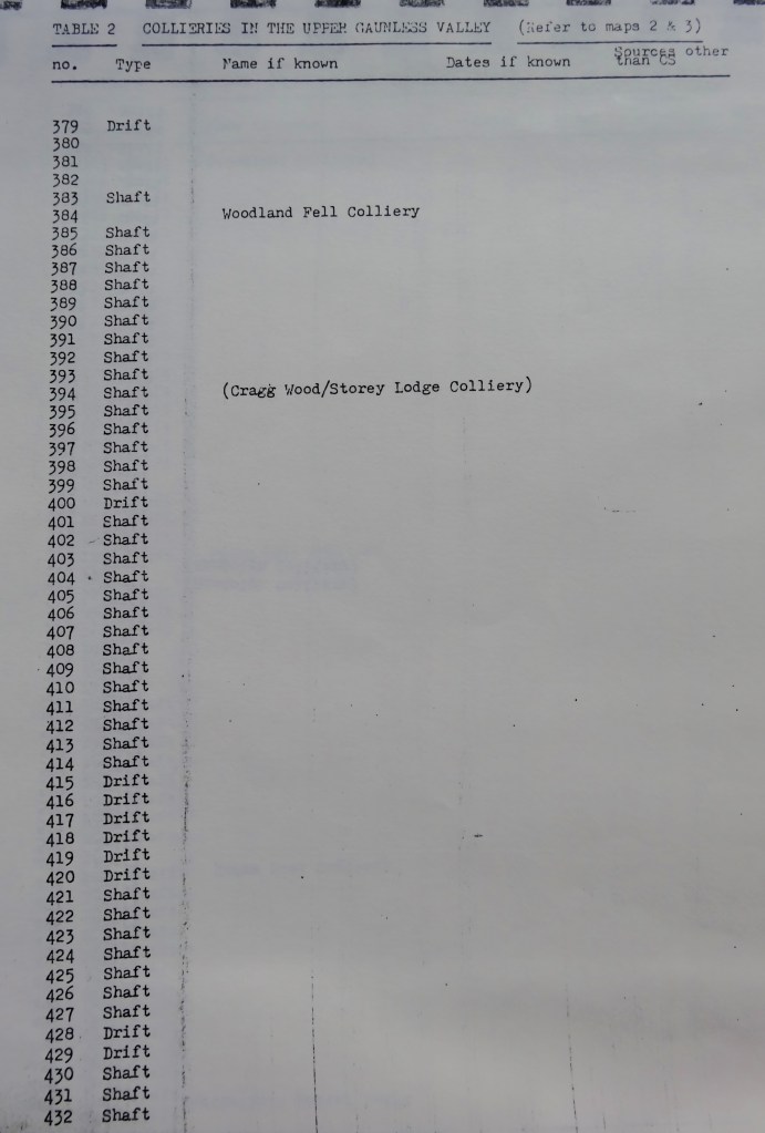
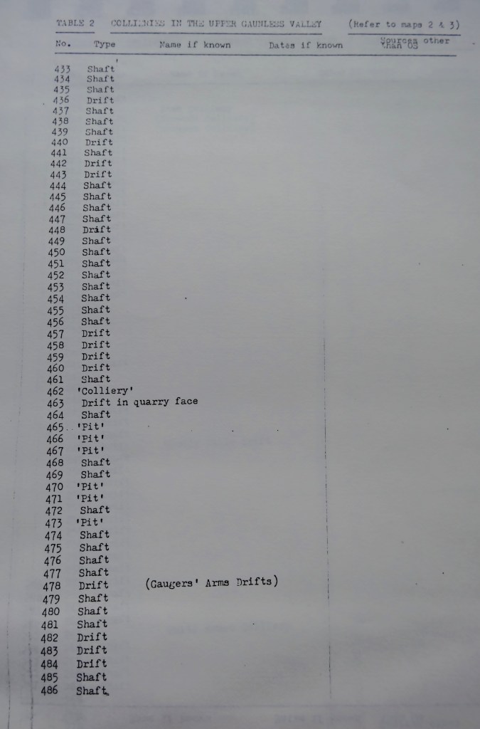
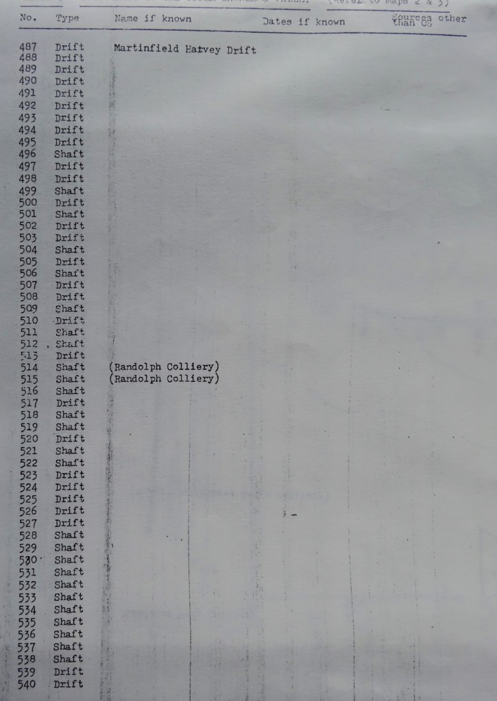
TABLE 2: COLLIERIES IN THE UPPER GAUNLESS VALLEY (Refer to Maps 2 & 3)


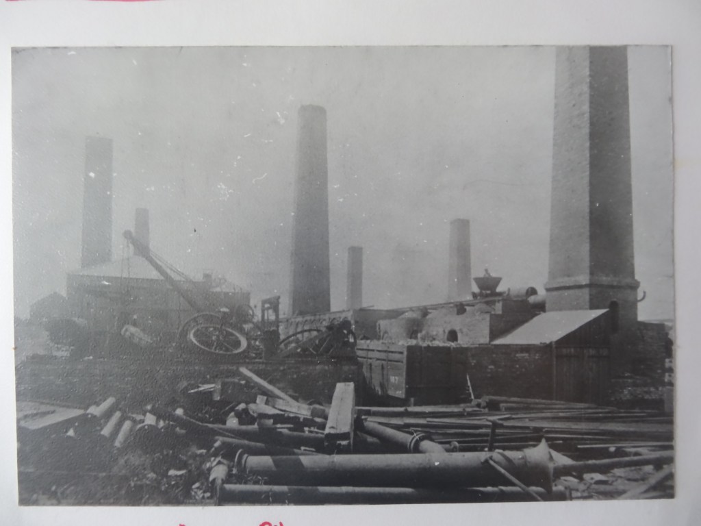
Above: Gordon House Colliery, Cockfield
BIBLIOGRAPHY
Ordnance Survey maps: 23”, 6”, 2½” and 1” to the mile.
Institute of Geological Sciences 6” to 1-mile OS based geological survey maps.
Industrial Railway Society “Industrial Locomotives of Durham – Handbook L” Published by IRS 1977.
D. Wilcock, “The Durham Coalfield – Pt.1 The Sea Cole Age” Durham County Council 1979.
K. Hoole, “A Regional History of the Railways of Great Britain – Volume 4. The North East” David & Charles 1965.
P.W.B. Semmens, “Exploring the Stockton and Darlington Railway” Frank Graham 1975.
C.R. Warn, “Rails Between Wear and Tyne” Frank Graham.

Above: Butterknowle DMA Banner
Below: Woodland DMA Banner

