In 1066, the Normans invaded England and took much of the south. The Northumbrians resisted and were subject to attacks which culminated in the winter of 1069/70, in what historians have called, “The Harrying of the North.” Its population was brutally dealt with by the Normans. A modern terminology would be, “a scorched earth policy.” There were also attacks from the north from the Scots. At the end of William I’s reign, 1087, only the castles at Newcastle and the Bishop’s castle at Durham existed as signs of Norman authority.
1081: William St. Carileph became the Bishop of Durham in the land between the Tyne and Tees and in 1091 given extensive powers. He could raise an army, appoint sheriffs, administer laws, levy taxes and customs, create fairs and markets, issue charters, salvage ship wrecks, collect revenue from mines, administer forests and mint coins.[1] The statistical survey of England undertaken in 1086 by King William I, known as, “The Doomsday Book” did not take account of land north of the River Tees.
1093: A building of a new Durham Cathedral is commenced and in 1104, St. Cuthbert’s body was buried there.[2] It was completed by 1132, taking only 39 years.[3]
Since 1093, the forests of Teesdale belonged to Guy Baliol and in 1107, he commenced building a castle, later known as Barnard Castle.[4]
1183 The Boldon Book [5]
As explained above, the ancient kingdom of Bernicia, the northern half of Northumbria was under the control of the See of St. Cuthbert, based at Durham. About 100 years after the Doomsday Book, in 1183, Bishop Hugh de Puiset (also known as Bishop Pudsey) compiled a report to assess the worth of his land. He was a nephew of King Stephen and was Bishop of Durham between 1154 and 1198.[6] This survey has been given the name, “The Boldon Book” otherwise known the Boldon Buke. There were notable exclusions in Durham:
- Land of the Baliols at Barnard Castle in Teesdale.
- Land of the Bruses in Hartness on the south east coast.
- Estates[7] granted to the Cathedral’s monastic community for its own maintenance such as Billingham.
- Freeholders of the Bishop.
The bishop’s land was occupied by:
- Demesnes, land attached to a manor and retained by the owner for their own use.
- Villain holdings i.e. a tenant with an area of land to tend.
Villages, as a grouping of homesteads, were introduced and a landscape of largely dispersed pattern of settlements developed at this time. Evenwood and Cockfield and the other villages of the Gaunless Valley are not mentioned in the Boldon Book. Did the Baliol estate extend over this area? Or were these villages and hamlets not a feature of the landscape? The nearest places to Evenwood mentioned are:
- West Auckland [8]
- Lutterington [9]
- Henknowle [10]
- Killerby [11]
- North Auckland (Bishop)[12]
- Escomb – there were 13 villeins. “A certain coal-miner holds 1 toft and 1 croft and 4 acres and provides coal for the iron-work of the ploughs of Coundon.” [13] Is this the first reference to a coal miner in south Durham?
The following map, (prepared by David Austin) shows places named in the Boldon Book. Adam of Selaby is mentioned in relation to land at Little Haughton[14] and therefore Selaby is indicated. Lucas of Barford is mentioned in relation to township of Barford and is indicated on the map but it is listed along with Stella, Winlaton, Sunderland, Westoe, Great Usworth and Herrington with seems somewhat of an anomaly.[15] Is it the Barford in Teesdale?
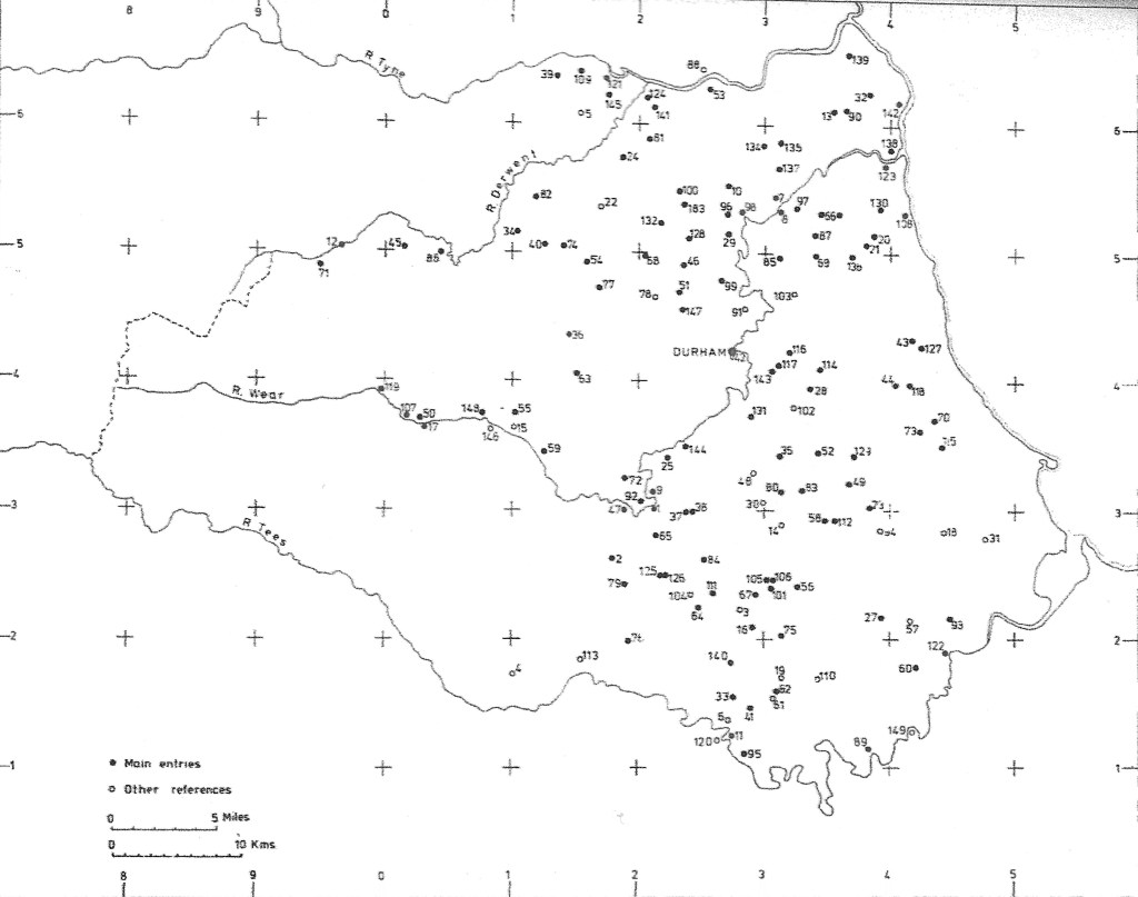
Above: 1183 Boldon Book Place Names
[1] Simpson p.94
[2] Simpson p.93-96
[3] Simpson p.101
[4] Simpson p.96
[5] “Boldon Book: Northumberland and Durham” 1982 edited by David Austin
[6] Simpson p.121
[7] Estates were sometimes called, “Shires.”
[8] Austin p.37
[9] Austin p.39
[10] Austin p.39
[11] Austin p.67 in relation to Heighington and grouped with Middridge
[12] Austin p.69
[13] Austin p.71
[14] Austin p.61
[15] Austin p.51
