PRE 1825 COAL MINING IN THE EVENWOOD AREA
Coal mining has taken place in southwest County Durham for hundreds of years. The opening of the Stockton and Darlington Railway in 1825 was the impetus for large scale development throughout south west Durham. Posts elsewhere on this website deal with the period after 1825. This post will look at early development of the industry and highlight key dates.
SECOND CENTURY AD
In 1977, excavations at Binchester (Vinovium) uncovered, “a pile of coal” in a pre-Hadrian level, placing the original deposit in the second century AD, if not earlier.[1] To the north of the County, coal, ashes and cinders were found at Lanchester and Ebchester. Both were locations for Roman forts located on Dere Street, one of the main roads leading to Hadrian’s Wall. These discoveries of coal are amongst the earliest in Britain.
ANGLO-SAXONS & VIKINGS
AD1031: King Canute (Cnut) restored land of the Gainford Estate, which included Raby, Scottum (Shotton), Cnaptun (Keverstone), Wacarfield (Wackerfield), Luterington (Lutterington) and Efenwuda (Evenwood) to the Church of St. Cuthbert at Durham. This provides evidence of occupation of our part of south west Durham. The area may have been populated but as far as is known, there is no evidence of coal mining.
THE MEDIEVAL PERIOD TO THE ENGLISH CIVIL WAR
The people of the Yorkshire and Durham suffered at the hands of William the Conqueror over the winter of 1069/70 in what became known as, “the Harrying of the North”. Symeon of Durham wrote that no village remained inhabited between York and Durham and even the countryside remained empty and uncultivated for 9 years. The Domesday Book of 1086 recorded that ⅓ of the land available for cultivation in Yorkshire was laid to waste.[2] Work associated with Domesday Book did not go north of the River Tees.
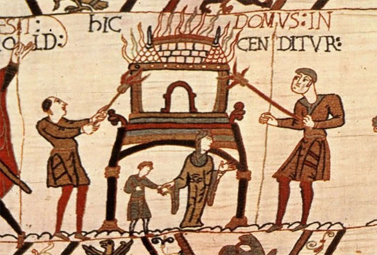
Above: The Bayeux Tapestry, Normans burning Anglo-Saxon villages
About 100 years later, in 1183, the Bishop of Durham, Hugh du Puiset (1125-1195) also known as Bishop Pudsey, instructed that a survey of his land be undertaken. This work became known as the Boldon Book, for no other reason that Boldon was the first settlement named. Only Lutterington of the above named settlements within the Gainford Estate was included in the Boldon Book. North (Bishop) Auckland, West Auckland, Escomb(e), Newton (Cap), Henknowle and Killerby are the nearest settlements to Evenwood with entries in the Boldon Book.[3]
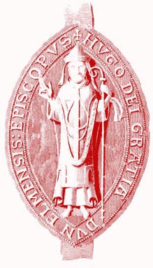
Above: The Seal of Bishop Hugh de Puiset (also known as Bishop Pudsey)
Mid way through the 14th Century, some 200 years later, it seems that the Bishops of Durham found it necessary to exploit the natural resources of their land. Coal mining took place and the following references provide evidence.[4]
Above: Sketch Plan to show the Sites of Coal Workings in County Durham between 1100 and 1550 under the auspices of the Bishops of Durham and Various Monasteries.[5]
KEY
- No.33 Evenwood 1368 & 1383
- No. 34 Softley 1362
- No. 35 Cockfield 1375
- No. 36 Railey Fell 1424
1362: Softley [6] Monks from Finchale Abbey had rights to mine coal which repaid them well in the next century, yielding a steady annual rent of £6 13shs. 4d.
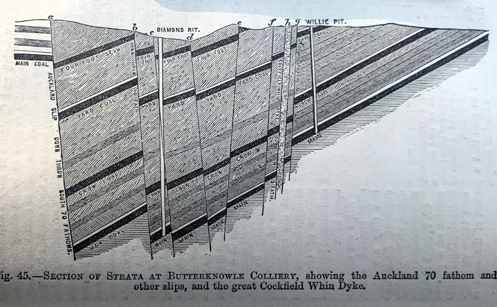
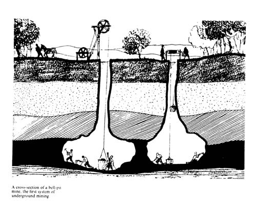
Above: Section of Strata at Butterknowle Colliery, South West Durham illustrating that some Coal Seams reach the surface which makes them accessible for mining using Bell Pits.[7]
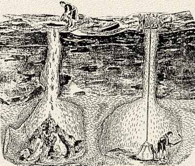
Above: An illustration to show Bell Pits, one being worked and one being filled with waste.
1368: Gordon and Evenwood Park [8] Bishop Bek granted permission for an iron furnace, called a “bloomestage.” This furnace may have used charcoal rather than coal for fuel.
1375: Cockfield [9] William Vavasour possessed a coal mine, “Carbonium Maritimorum”, valued at 20 marks. This is the first recorded sale of a coal mine in inland Britain.
1383: Evenwood [10] A colliery was being worked at this time.
Above: Bell Pits, 2 more illustrations
1424: Raly [11] It comprised the mines of coal and of iron ore under the coal, in Raly, Caldhirst, Hertkeld, Hethereclough, otherwise Tollawe and Wollawes, and in the barony of Evenwood. The lease was first held by Rauf de Eure (“eure” meaning ore) and upon his death in 1424 it was granted by Bishop Langley to William de Eure for a term of 9 years. The de Eure family were residents of Witton Castle, south of the River Wear. The lease was renewed by William de Eure on several occasions, by successive bishops. Among the conditions were the following requirements (covenants):
- The lessee at his own cost should protect, support and uphold the water gates required for the mines
- The lessee should leave the water gates and any others in good order at the end of the lease
- The lessee at his own expense sink the pits (puyttes) required for the winning and drawing of coals from the mines
- Coals only to be drawn on lawful working days
- The lessee was required to deliver annually on the surface as much coal as the bishop should deem necessary to Auckland Castle at the price of 4d per chaldron.
- The bishop granted the timber necessary for the water gates from his woods.
- The bishop may consider bearing half of the cost of the water gates should they incur any remarkable expense.
- The bishop would not allow anyone else to make water gates on his ground or carry coals on his ground except by byways to the injury of the lessee.
1440: The Chief Forester for Bishop Neville, appears to have been responsible for collecting the rents and other income from the coal leases, by being appointed to the position of, “bankmanship” of the coal mines of Ralifield. A figure of £112 13shs 4d was due from the mines at Raly, Caldehirst and Hethereclough. It is evident that the mines at Whickham and Gateshead in the north and Raly, Hethereclough and Caldehirst in the south of the county were far more valuable than any others.
William de Eure exorcised a long tenure, worked the mines with vigour and had a considerable trade over a large area. Perhaps the working of Railey restricted the profitability of the Softley mine operated by the Finchale monks. It appears that William de Eure may not have honoured the terms of his lease and on several occasions, proceedings were taken against him:
- 1450-51, Bishop Neville directed Henry Lescrop and others to inquire into the cutting of “forbarres” (barriers?) by de Eure or his servants, in the working mines.
- 1458-59, Bishop Booth assigned Harry Preston and others to investigate damages and wastes said to be committed by de Eure and his servants in the coal mines of Raly.
- 1463-64, Bishop Booth directed the Sheriff of Durham to arrest and detain certain men from the Counties of York and Durham and the wapendyke of Sadberge, they having taken coal from a pit of William de Eure, a knight of “Les Toftes”, with carts and horses etc. and injuring the soil and grass of the Bishop.
1478: Sir William de Eure leased, “Raley, Tofts, Caldhirst, Hertkeld and Hetherclough” for 11 years at the annual rent of £150. The terms of the lease had differed little from 50 years earlier. All expenses were to be borne by de Eure although he was permitted to take timber and granite from the Bishop’s land for the support of the pits. The output was limited to 31 tons per day at Raley, 27 at Tofts, 5 at Hertkeld and not more than 2 additional tons at any other mine he might work. Thus, the 2 pits at Raley and Tofts accounted for 85-90% of the output. Other clauses included:[12]
- There was no provision for making up the short output from any other mine.
- The pits could only work on days and nights which were usual in the Bishopric – no working was permitted on the Sabbath, nor for a period of 40 days in midsummer (presumably, the men were required for farming duties).
- If noxious gasses (called “the styff”) prevented him from getting his full quota in a working day, he could make up the shortage the following day, only at the same pit.
- He must not touch the seam underground within “4 rods” of the boundary of the Bishop’s manor. He was required to leave sufficient “forbarres” 4 rods in breadth.
- The Bishop was entitled to as much coal as pleased him for his lodging at Auckland and elsewhere in the Bishopric at the cost of 4d per cartload (a sum which just about covered the cost of mining). The Dean of Auckland was also entitled to coal at 2d per cartload. While new shafts were being dug, or being repaired, in the major winnings, the Bishop stipulated that his and the Dean’s coals must then come from Hertkeld. The Bishop made the most of his unlimited right to coal.
- If the lessee could not find a market for the coal, he was still required to pay the full rent – it should be noted that during the Winter months, transporting coal overland by pack horse or cart was nigh-on impossible therefore income would have been negligible.
On the credit side, de Eure was guaranteed a virtual monopoly of the coal trade into Yorkshire. If it assumed that there were 250 actual working days in the year, it was estimated that the maximum annual output permitted was 16,000 tons. It is estimated that the “royalty” extracted by the Bishop amounted to about a third of the pithead price. [13]
Having held the lease for a period of about 60 years, the de Eure family were succeeded by Robert Walker.
1485: Bishop Sherwood leased the mines of Raly, Caldhirst, Toftes and Hartgyll to Robert Walker for one year at a rent of £150.
1488: The mines of Raly, Toftes, Caldhirst, Hartkeld, Hetherclough, otherwise Tollawe, Morapitt, Ceple and Wollawe were leased by Bishop Sherwood to Robert Walker for a term of 6 years and a rent of £141 6shs 8d per annum.
The great lease of South Durham coal mines continued almost in its original form during the whole of the 15th Century and into the 16th Century.[14] Whickham has been described as the most productive colliery in England during the 15th Century. Almost equally profitable pits were being worked in South Durham to the west of Bishop Auckland at Raly near Evenwood and westward at Softley.[15]
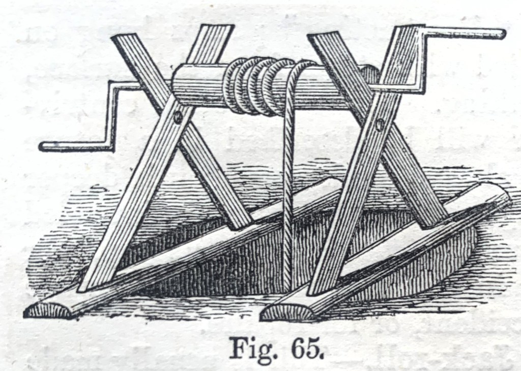
Above: A simple windlass used for hauling corfes of coal
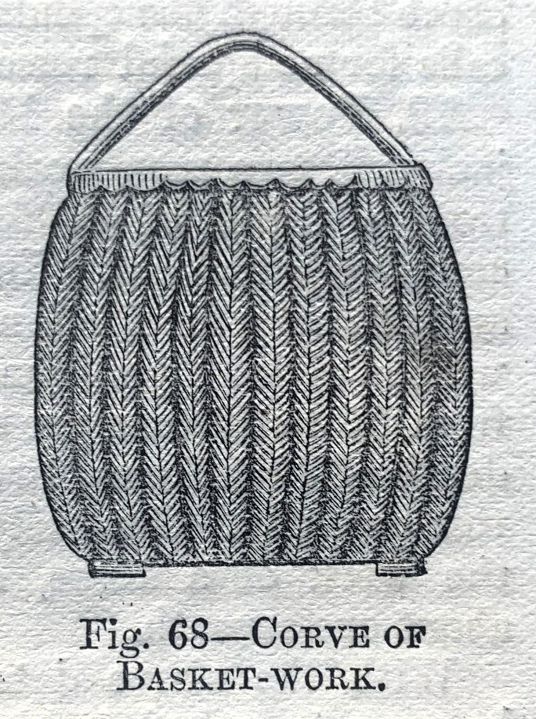
Above: A Corf (corve) of basket work
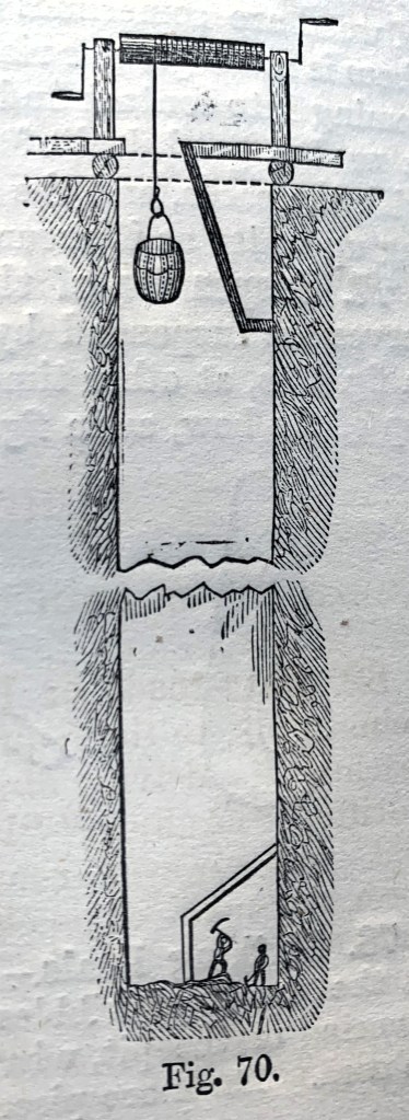
Above: An illustration to show a simple underground mining operation
1525-26: The coal mines and pits of Grewburn and Raile were leased to Margaret Symson of Henknoll, widow, Richard Bellasys of Walworth and Bartholomew Harwode of Barnard Castle for 30 years at £180 per annum. They continued to be of equal, if not greater importance, than the previous century. Coal was supplied to a large district of North Yorkshire. It was reported that most of the coal supplied to the town of Richmond was brought from the Rayle pits near Auckland. [16]
1551-52: The above lease was not worked for the full term and Bishop Tunstall leased the coal mines of Grewburne and Raillee to Anthony Tydeman for 26 years at £150 per annum. The mines were of a lower value than the earlier lease. Tydeman was subject to various inquiries:
- 1553-54: He and 2 others were charged by the king and queen’s Attorney-General with intruding on the manor of Softley.
- 1560-61: The Dean of Durham and others were appointed commissioners by Queen Elizabeth to inquire into the quantity of coal won by Tydeman at Raley and Grewburn, Toft, Hargyll and also to ascertain its value.
Between 1551 and 1560, it was estimated that the annual production of coal in Durham and Northumberland was 65,000 tons.[17]
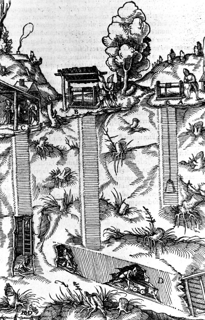
Above: 1556 Illustration from Georgius Agricola de re Metallica[18] showing a method of underground coal mining
1568-69: The above lease was not worked for the full term. Bishop Pilkington granted a 21-year lease to Henry Smythe to work the coal mines at Rayley for the rent of £10 per annum. Having existed for about 150 years, the Rayley lease appears to have lost its importance since its value had fallen significantly, from £150 to £10 pa. Among the covenants was one which stated that if coal ceased to be found then the rent shall no longer be paid. This infers that the lessee was concerned that the reserves of coal may have been exhausted. The above named Henry Smythe (Smith) may well have been a leading developer of the coal industry since another person of the same name obtained a lease from the Bishop of Durham to the north of the county at Whickham, south of the River Tyne.
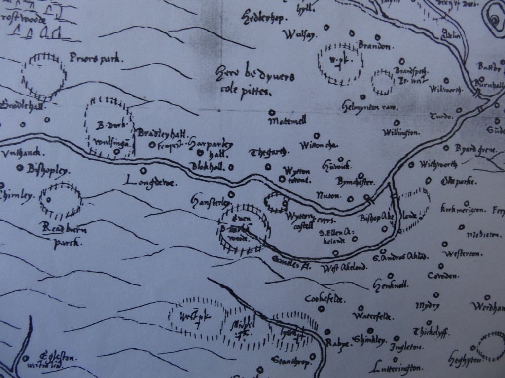
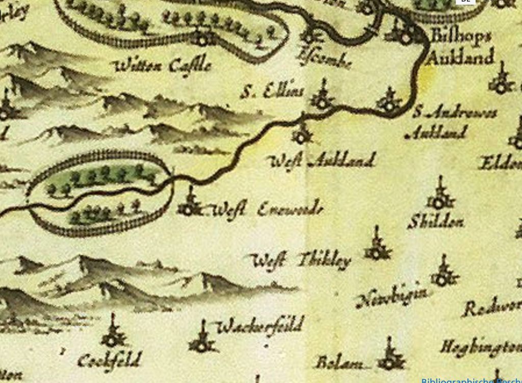
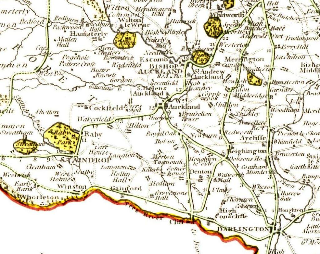
Above: 1569 A Detail from Cecil’s Map which shows Evenwood Park, to the north east Witton Castle Park and to the east Auckland Castle Park
1580: The pithead price was 1sh 4d per wainload (about 17½cwt.) to inhabitants of the Bishopric and 1sh 8d to outsiders. The Dean of Auckland was accustomed to take about 70 wainloads yearly.[19]
1580: Commissioners examined the depositions of the dissolved Auckland Deanery regarding:
“tythes and coals of Raly pitts and other tythes, Ralyfell, Hardhill, Grewborne, coal pits in the same deanery.”
1581: A similar enquiry took place, appertaining to the coal pits of Ralifell and Carterthorne.
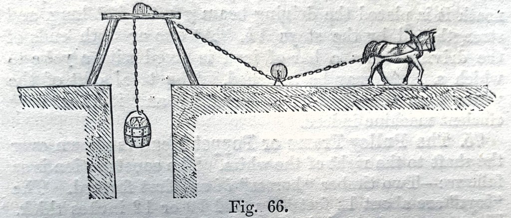
Above: An illustration to show horse power engaged to lift corves.
1587-88: When the lease was up for renewal, Smith paid £107 16shs 8d per annum for the right to work Raly, Hargill and Grewborn pits, substantially more than 20 years earlier. His principle achievement had been the opening of a new mine at Carterthorne.[20]
1595: Cockfield, another colliery had come to some prominence and was taken over by Henry Rosse, a London merchant. He sublet it 2 years later to 2 Newcastle merchants and by doing so, obtained a healthy annual profit, over and above the Bishop’s rent.[21]
1598: By his will dated 20 July 1598, Henry Smythe (Henry Smith) granted all his coal mines, then having a yearly profit of £100, to the City of Durham.[22] This return was only exceeded by the larger collieries on the Tyne.[23] Most of Smith’s mines continued throughout the 17th Century to produce substantial supplies of coal.
1611: Cockfield, the Crown held a “landcoal pit,” with the annual rent of £4 and yearly value of £40.[24]
1632: Softley, mine owners often built a pathway (coal road) from their pits to the nearest byway and there is a record of “railing or repairing” such a way at Softley costing £7 or £8.[25]
1635: Carterthorne, a rent of £70 pa was paid by the lessee Lord Eure. The Mayor of the City of Durham paid £20 for Grewborn pit and £18 for Hargill pit (bequeathed to him by Smith). [26] It is evident that the de Eure family were still active in the coal industry, about 200 years after their introduction.
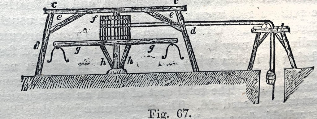
Above: An illustration to show another mechanical development used for raising corves.
THE ENGLISH CIVIL WAR 1642-48 AND BEYOND
Similar to development around the Tyne and Wear rivers, mining in south Durham grew at a rapid rate. The seams nearest the market were dug to such considerable depths, that it became profitable to sink new pits to shallower seams, somewhat further away. Savings in mining costs more than made up for transport costs. By the time of the Civil War, a second line of workings was established at Shildon, Coundon, Auckland Park, Etherley, Softley and Hamsterley.[27]
Above: 1646 A Detail from Bleu’s Map to show Evenwood Park, Witton Castle Park and part of Auckland Castle Park.
1646: Carterthorne was sublet for £350 pa, over and above the Bishop’s lease.[28]
1647: A survey of the Manor of Evenwood presented to the Bishop of Durham records Carterthorne Colliery leased to Mr. Drake, Mr. Charles Vane and Mr. Thomas Bowes:[29]
“that there is a great colleyerie within the Manor called Carter’s Thorne which is in lease from the Bishop for the lives at the rent of £70 pa. and letten by one Mr Drake who is said to be feoffee or trustee for some children who pretended to have right upon the said lease now let for 3 years to Mr Charles Vane and Mr Thomas Bowes for £350 pa.”
There is mention of another colliery at Butterknowle, but, “of very little worth”.
1649: The Crown’s pit at Softley had been largely unworked since the beginning of the 16th Century. It was still an unprofitable venture in 1632 because of competition from the Bishop’s pits at Railey and Hamsterley. However, the Parliamentary Commissioners found that there had been a marked improvement in this colliery, then known as the, “King’s Collyrie in Lanton Hills”, and it was estimated that it lay under 400 acres of surface area.[30]
1667: Etherley, of little value before the Civil War, the Bishop of Durham now leased the mine for £1,100 pa. Coal was sold at the pithead for 2 or 3 shillings per ton, and given the overheads it is estimated that the output was in the order of 10,000 tons pa. By the end of the 17th Century, it is thought that there were at least 2 pits in the area – Carterthorne and Etherley, producing such an annual output.[31]
1687: Ramshaw, Gordon, Morley and Toft Hill, Thomas Langley entered into a lease with the Bishop of Durham. Also the Greenfield lease was let at this time. [32]
1700: The largest coal mine undertakings demanded reserves of £15-20,000.[33]
1714: An agreement between the Bishop of Durham, Nathaniel Lord Crewe and Thomas Peirse (of Hutton Bonville, Yorkshire) to work land at Railey Fell, otherwise referred to as Carterthorne Colliery, for the lives of his children William, Richard and Anne Peirse.[34] The lease included the following covenants:
- The yearly rent of £70.
- A ½ penny for every horse load and 4 pennies for every cart load of coal.
- To supply the Bishop with good coal.
- To leave pillars underground (to prevent subsidence).
- To work no more than 3 pits without a special licence.
- For the Bishop’s representative “to view” the mines (in order to check that the pit was being worked in accordance with the terms of the lease.)[35]
1725: Lord Harley commented upon the streams of pack-horses that he encountered all along his route from Darlington to Bishop Auckland.[36] This was further evidence of the regular trade in coal from south Durham into the Tees Valley which had existed since the 15th Century. At Darlington, coal brought 10 miles from Etherley Colliery cost four times the pithead price, thus it seems to have doubled every 2 miles it was carried from the pit.[37]
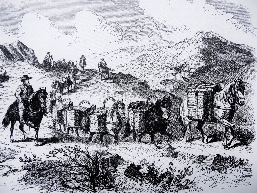
Above: An illustration to show a convoy of pack horses
1751: Improvement of the highway system was commenced in the North East of England during the 18th Century when the new “turnpike roads” were introduced. Such schemes included the following road improvements – in 1745, Boroughbridge to Durham (the Post Road), in 1747 Stockton to Barnard Castle and in 1748 Bowes to Sunderland Bridge. This road (now the A688) passed through Evenwood Gate. The Etherley to Darlington road, (now the A68), benefitted from such works which were authorised by the Act of 1751, described as follows:
“Act for repairing the High Road leading from Darlington in the County of Durham to West Auckland and several other roads in the said County therein mentioned.”
This highway was known as, “The Coal Road.” The preamble to the Act stated that there were coal mines belonging to Sir Robert Eden at Greenfield and William Peirse Esq on Rayley Fell, “nigh to Red House”.
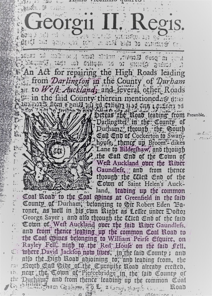
Above: The front page of the Act which permitted Improvements to, “The Coal Road”
1767: It was recognised that even better communications were necessary if the inland coalfield around Bishop Auckland was to be developed. Meetings of local businessmen took place.[38] A canal from Stockton-on-Tees to Winston was suggested to the Duke of Cleveland by George Dixon of Cockfield in order to convey coal from the local pits to the port on the River Tees. This scheme failed to gain support.
1781: An agreement was made between Charles Fawcett, Recorder of Newcastle-upon-Tyne & John Flintoff and Richard William Peirse to work Railey Fell, Bitchburn and Brusselton Collieries.[39] The term of the lease was 31 years from 1 December 1781 which took the agreement to 1812. Mr. Flintoff could give up the lease after 7, 14, 21 or 28 years (i.e. 1788, 1795, 1802 or 1809). The main terms were:
- Mr. Flintoff could mine 9000 scores of corves from Railey Fell Colliery, (22 corves to the score, 8 pecks to the corf), for which he paid an Annual Rent of £800 in quarterly payments whether that quantity was achieved in any one year or not.[40]
- 2000 scores from Bitchburn Colliery, for which he paid £100 per annum by quarterly payments.
- 2000 scores from Brusselton Colliery for which he paid £100 per annum by quarterly payments.
- Mr. Flintoff agreed to pay for overworking at Railey Fell Colliery at the rate of 2 shillings per score and for the overworking at Bitchburn and Brusselton Collieries, 1 shilling per score.
- Mr. Flintoff was at liberty to give up Brusselton Colliery at the end of any year during the term by giving notice of 12 months.
- The farm belonging the colliery to be taken by Mr. Flintoff at a fair rent to be valued according to the rate of the farms in the neighbourhood.
- Mr. Flintoff to supply the Bishop of Durham with coal at Auckland Castle on being paid by the Bishop 1d p (per) horse load and 4d per cart load.
The subsequent agreements associated with this lease took the workings of this pit up to 1811 with the final term expiring in December 1826. It is understood that the Stobart family then took over part of the lease and worked the Railey Fell collieries.
Above: 1787, a detail from Carey’s map to show, “The Coal Road” leading from Darlington to Red House, Etherley.
1796: Norwood Colliery, the land was owned by the Earl of Strathmore and the pit was worked by Messrs George and John Dixon and John Flintoff. The plan of the colliery shows a number of pits including Lane Side Pit, East Field Pit, Quick Hedge Pit and Dyke Pit. A water course led down from the colliery to an engine then to the River Gaunless. There were 2 roads leading to the colliery, one from Butterknowle Lane (now recognised as Low Lands) and one from Evenwood Bridge, then known as Norwood Lane and identified as a, “coal road”.
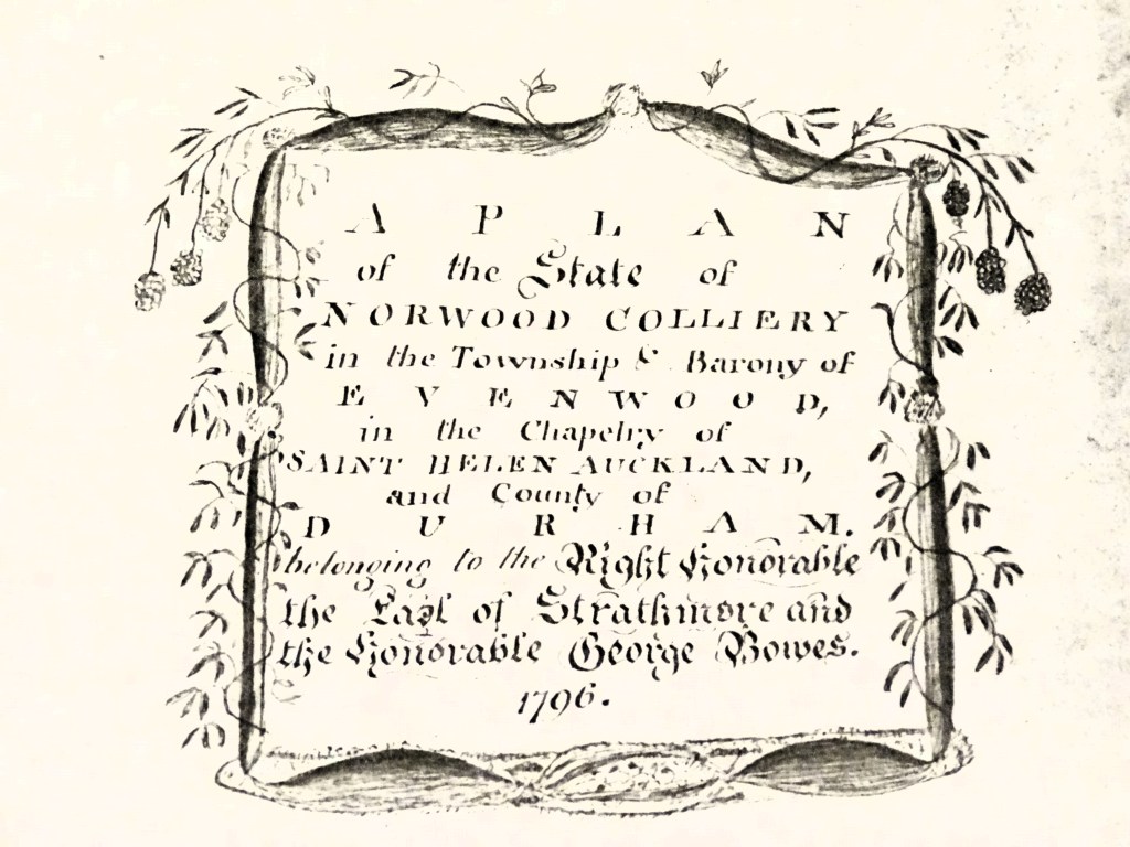
Above: 1796, the Title Block for the Norwood Colliery Plan.
1803: Norwood Colliery, a sketch map shows it being worked by a number of pits including Engine Pit, Hedge Pit, Doghole Pit and 2 “old pits” are shown.
1804: Norwood and Ramshaw Collieries, a report was prepared by William Stobart dated 13 July for the Bishop of Durham into the lease belonging to the Earl of Strathmore. It stated that workings were, “difficult and troublesome” and suggested that some devices were required to drain water if further extensive mining was to be carried out.
1807: Ramshaw Colliery. A report prepared by William Stobart for the Bishop of Durham stated: [41]
“Ramshaw Colliery (a part of the same lease as that of Norwood) is at present carried forward by means of a Fire Engine that frees the mine of water, lifting the same into an offtake delivery drift to the Engine Pit from the River Gaunless. The boundary of the coal to be obtained at Ramshaw by the present winning is only of small extent being confined by the Greenfield Lease on the east and that of Railey Fell on the north and west and what may be got to the south seems uncertain as no proofs have yet been made of the coal keeping good to any considerable distance.”
At this time, the lease was granted to the Earl of Strathmore.
1811: Peirse perambulated the boundaries of Railey Fell 31 October.[42] This means that he or his representatives walked around the area in order to officially assert and record its boundaries.
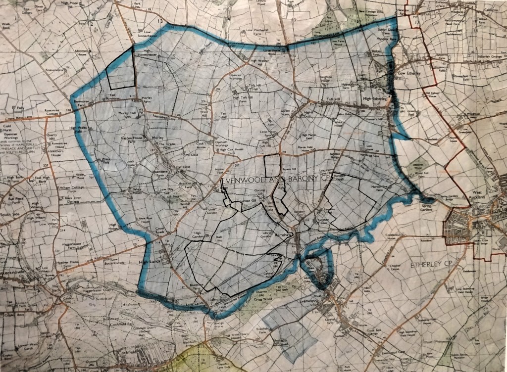
Above: 1765: The Allotment Plan for Railey Fell – defined by the area edged and coloured blue, basically the land to the north of the River Gaunless within he Parish of Evenwood & Barony.
At this time, interest in transport improvements increased. This subject has been well documented by others. Only significant dates where there is an Evenwood, Railey Fell or Norwood connection is mentioned in this work. Various references have been used.[43]
1818: A scheme designed by Leonard Raisbeck for a tramway or railway to connect the River Tees with the Auckland Coalfield received support. Subsequently, various schemes were designed and finally the 35-mile route from Stockton-on-Tees to collieries at Etherley, Greenfield and Norwood was put forward.
1821: Royal Assent to the scheme was granted 12 April. It was known as the Stockton and Darlington Railway.
1822: In May, the first sod was cut for the Stockton and Darlington railway.
1823: The Stockton and Darlington Railway Bill. The Earl of Strathmore petitioned against the Bill in order to make sure that the company lay down the projected Evenwood Branch so that coals from the Norwood Colliery could be served by the railway. Rev Luke Prattman also petitioned so that a link to his collieries at Butterknowle linked in to the railway. An agreement was reached and the line struck off at St Helen Auckland to Evenwood Bridge rather than Norlees House to Evenwood Lane.
1823: Revised plans were submitted in September to the Quarter Sessions to show a, “new or additional branch” to serve the Norwood Pit located to the north of Low Lands Farm, north of the River Gaunless.
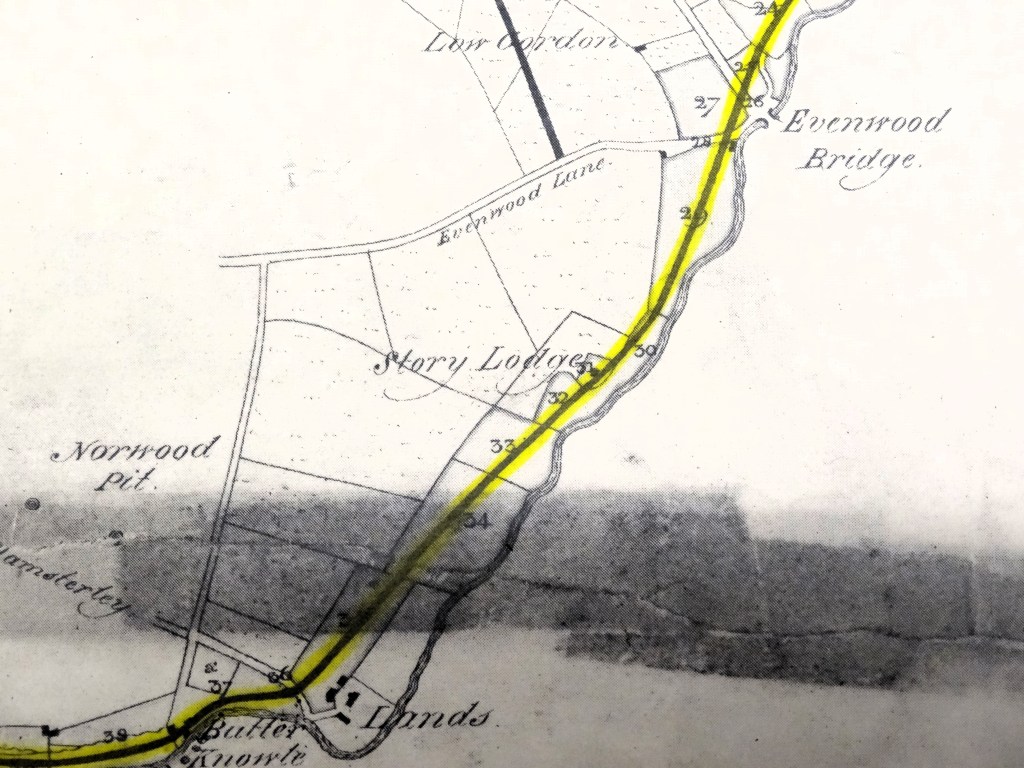
Above 1823: A detail from Dixon’s map to show the revision of the route to Haggerleases Lane. Norwood Pit is clearly shown.
1825: The official opening ceremony took place 27 September. This allowed coal to be transported directly from the pithead at Phoenix Pit, Etherley to the port at Stockton-on-Tees.
The following account of the Auckland Coalfield was provided by Joseph Lowson of St. Helen Auckland in 1842: [44]
“This district may be said to commence at Coundon, a little to the east of Bishop Auckland and extends westwards to Butterknowle Colliery, a distance of 10 miles…not less than 70 square miles of surface…Within the last 20 years, considerably under 100 coal workmen were all that were engaged in the district getting coals and the whole of the produce of this important coalfield was carried away, and a portion of it to very distant markets too, either in carts or on the backs of mules or asses. Large numbers of them taking the by-roads in order to secure a little of the scanty herbage and avoid the payment of gates, were in those days met, carrying two or three bags of coal each. They frequently found their way to a distance of 50 miles from the pits, where from the excellent quality of the coal, a ready market was secured.”
During the first quarter of the 19th Century, the collieries of South Durham worked in a highly primitive condition. However, with the coming of the railways, all was to change: [45]
“the district was now to be awakened from its slumbering medieval simplicity.”
REFERENCES
[1] “The Durham Coalfield” Wilcock D.
[2] https://www.historytoday.com/history-matters/harrying-north
[3] “Domesday Book Supplementary Volume 35 Boldon Book Northumberland and Durham” 1982 edited by John Morris
[4] One writer stated, “The amount of material available for the history of the Durham coal mines during the 15th century is so abundant that a rigorous selection is necessary, and all that can be done here is to supplement with a few particulars, hitherto unpublished, the valuable account furnished by R.L. Galloway”. It follows that most of the references in this account are from the research carried out by R.L. Galloway and published in 1898.
[5] “Presidential Address to the Institution of Mining Engineers” 1910 Simpson J.B.
[6] “Annals of Coal Mines and the Coal Trade” (2 vols.) 1898 Galloway R.L., Vol.1 p.53 from “Priory of Finchale” Surtees Society vi, xxxi
[7] “Principles of Coal Mining” J.H. Collins 1876 p.47 Other illustrations in this section are from this source.
[8] “History, Topography & Directory of the County of Durham” 1894 Whellan & Co.
[9] “The Victorian History of the Counties of England. Vol. II History of Durham” edited by W. Page & Galloway p.54
[10] Page & Galloway p.54 & Wilcock p.67
[11] Galloway p.72 & 73 Note: Raly otherwise known as Railey Fell, Raly Fell, Raley, Railee and other spellings.
[12] Nef p.137 & 138
[13] Nef p.139
[14] Gallaway p.105 & 106
[15] “Durham County and City with Teesside” 1970 edited by J.C. Dewdney p,208
[16] Leland’s Itinerary 1768 edition
[17] “The Rise of the British Coal Industry” 1966 R.U. Nef p.19 Table 1. Note: It should be pointed out that Nef was cautious about the accuracy of his estimates. He quotes, “Raby” on many occasions but it is believed that he has misinterpreted Raby for Raly. Raby is not located on the coal field, whereas, “Raly” (as in Railey Fell and similar spellings) is some 4 miles or so to the northeast, within Evenwood Barony. Railey is clearly situated on the coal field and for centuries, has been subjected to coal mining.
[18] “Georgius Agricola de re Metallica; translated from the first Latin edition 1556 with biographical introduction, annotations and appendices upon the development of mining methods, metallurgical processes, geology, minerology & mining law from the earliest times to the 16th Century” by H.C. Hoover & L.H. Hoover 1950
[19] Nef p.137
[20] Nef p.38
[21] Nef p.38 from Star Chamber Proc. James I 265/3 See also Ministers’ Accounts, Elizabeth no.661 for information relating to Cockfield and Evenwood.
[22] Gallaway p.106 from the Industrial Resources of the Tyne, Wear and Tees, Second Edition, p.233
[23] Nef p.38
[24] Nef p.146 Note: “landcoal” meant coal raised and carried for local sale.
[25] Nef p.382
[26] Nef p.38 & 154
[27] Nef p.38
[28] Nef p.38
[29] “1647 Parliamentary Surveys of the Bishopric of Durham” Surtees Society Vols. 183 & 185, 1971-72.
[30] Nef p.39 from Parliamentary Surveys, Durham no.6 (November 1649)
[31] Nef p.39 from “Chronicles of the Coal Trade of Durham and Northumberland” Green p268-9
[32] “Chronological Records of Coal Mining, Transport etc. in Northumberland & Durham from AD1180 to 1839” 1943 CWS Printing Works.
[33] “Seacoal Lane from Tyne to Thames” 1947 Coal Magazine J.D.M. Bell p.10 &11, an article in the series. “History of the Coalfields, Northumberland and Durham.”
[34] Full details of this agreement and other documents appertaining to the working of these collieries is provided elsewhere on the website.
[35] “The Viewer” was a term in common use during the 1800s to describe what we would now call, the Colliery Manager and was the precursor to the profession of the mining engineer. Details from the Catalogue of Plans of Abandoned Coal Mines record the following abandoned, unnamed seams – 1726 Butterknowle, 1768 & 1771 Auckland West, 1781 Brusselton, 1781 Etherley/Railey Fell, 1781 Tees West/Railey Fell and 1831 Woodland. This shows that records were kept by Colliery Viewers from the early days of the industry when given the terms of the leases and the highly dangerous nature of the work, it was essential that detailed plans of the workings were kept.
[36] “Journeys in England” 1725 Lord Harley, Nef p.102
[37] Lord Harley, quoted by Nef p.103
[38] “Stockton and Darlington Railway 1825-1875” Holmes P.J. undated
[39] Full details of this agreement and other documents appertaining to the working of these collieries is provided elsewhere on the website.
[40] £800 is about £176,000 today and £100 about £21,920 today.
[41] Durham University Department of Palaeography and Diplomatic, Church Commission 212911 (Box 165)
[42] “History of County Durham” 2 Vols. 1857 Fordyce W.
[43] Holmes for example
[44] “Series of Views of the Collieries of Northumberland and Durham” 1844 Hair TH. & Ross M. p.47 note.
[45] Galloway p.452
