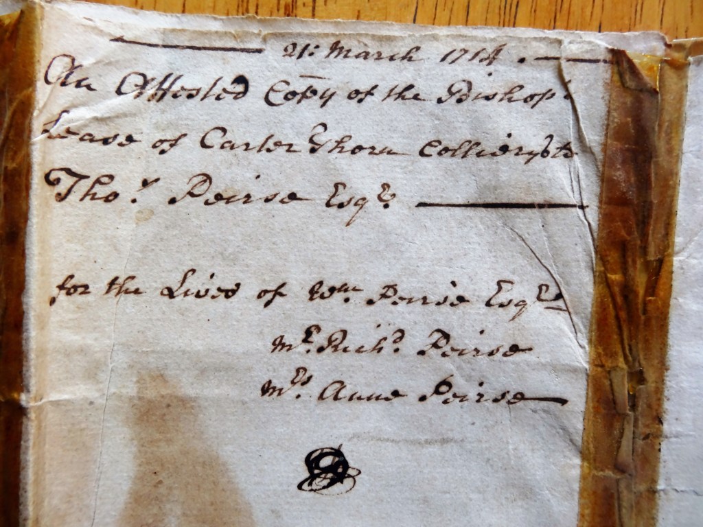
Above: A Detail of a page from the Lease
A BRIEF SUMMARY
21 March 1714: An agreement between the Bishop of Durham, Nathaniel Lord Crewe and Thomas Peirse (of Hutton Bonville, Yorkshire) to work land at Railey Fell, [1] otherwise referred to Carterthorne Colliery. For the lives of:
- William Peirse, eldest son of Thomas Pierse then aged fourteen years or thereabouts.
- Richard Peirse
- Anne Peirse, eldest daughter of Thomas Peirse then aged thirteen years.
The terms of the lease included the following:
- The yearly rent of £70.
- A ½ penny for every horse load and 4 pennies for every cart load of coal.
- To supply the Bishop with good coal.
- To leave pillars underground (for safe working and to prevent subsidence).
- To work no more than 3 pits without a special licence.
- And for the Bishop to be able “to view” the mines.[2] (To check that the pit was being worked correctly.)
The Bishop’s attorneys were John Hodson & Calverley Pinkney.[3]
There are 2 other dates on the document which are:
13 May 1715: A date was required to confirm when the pit was opened up. Carterthorne Pit was the name given to the new winning. The details were confirmed by John Hodson and others including John Richardson of Witton-upon-Wear who may have been Thomas Peirse’s representative.
22 June 1734: Refers to a true copy of the original lease – why was it examined then? The lease had not run its course since, as it transpired, Thomas Peirse died in 1753, his sons William died in 1753 and Richard died in 1759. No date has yet been confirmed when his daughter Anne died. Anne Peirse married Richard Hodson of Witton-le-Wear.[4]

Above: A Detail of the First Page of the Lease
WHO WAS THOMAS PEIRSE? [5]
The Peirse family originally came from Bedale in North Yorkshire. Their pedigree dates back to the 15th Century when Peter Peirse of Bedale was a standard bearer for Richard III at the Battle of Bosworth Field, 1484. Not related to royalty but they can be described as, “old money,” and a family of influence holding a Coat of Arms.
Thomas Peirse’s father was Richard Peirse, originally a merchant from Stockton-on-Tees, who acquired property at Hutton Bonville and Thimbleby, near Northallerton in North Yorkshire. Thomas married well – Anne Hustler, eventually co-heiress, with her sisters, to her father’s estate, Sir William Hustler of Acklam. Thomas also benefitted from his own inheritance. Thomas and Anne are believed to have had 10 children. William, Richard and Anne are mentioned in the above lease. The children were:
- William Peirse (bc.1700, died 1753) of Hutton Bonville and Thimbleby eldest son and heir. In 1726, he married Dorothy sister of Joseph Stillington Esq., of Kelfield, Yorkshire.
- Richard Peirse Esq. (bc.1701, died 1759) He was a merchant at Stockton-on-Tees, Co. Durham. He married Rachel, sister of William Bayne Esq.
- John Peirse (died 1734) He lived at Low Worsall and Newport in Cleveland. A merchant who in 1733, with his brothers, Richard and Thomas, purchased the land of William Wilkinson at Worsall on the south side of the River Tees, a few miles upstream from Stockton at the river’s highest tidal point where they built a stone wharf and a warehouse. For many years they ran a profitable agricultural trading business which extended as far as Scandinavia and Portugal.[6]
- Thomas Peirse of Kirk Levington, who under the will of his aunt Evereld Hustler, assumed the surname, the arms and wealth of the Hustler family.
- Anne Peirse, (bc. 1701 date of death unknown) married to Richard Hodson Esq., of Witton-le-Wear, Co. Durham.
- Mary married 6 February 1728 to Joseph Stillington Esq., of Kelfield, Yorkshire.
- Evereld, died 1761, unmarried, buried at Hutton Bonville chapel.
- Catherine Peirse died 1760, unmarried buried at Hutton Bonville chapel.
- Dorothy – no details.
- Elizabeth – no details.
William, Richard and Anne (and their descendants) benefited from their fathers’ business acumen, 100 years or so before the opening of the Stockton and Darlington Railway in 1825. To sum up, the Peirse family was well connected to the wealthy of North Yorkshire and were well positioned to benefit from the impending industrial revolution brought about by the need for coal and developments in transportation, that is the exploitation of coal and the growth of railways in South Durham and the explosion of the iron and steel industry along the Tees valley.
The granting of the 1714 lease to work coal at Railey Fell was a precursor to the riches that would follow. An astute business transaction by Thomas Peirse which was to be followed by other similar deals.
Above: The Peirse Coat of Arms
WHERE IS RAILEY FELL?
The area of Railey Fell is defined in the lease as:
“lying and adjoining on the East part of the Moore Close and Escomb Hirst on the North East to Escomb Carr adjoining to the Park late the Lord Ewerd called Witton Park and the West Park adjoining to Lingburne[7] and Rowntree Pitsand to the four rock of Stones in the Height of Butterknowle, and on the South along to Baron Dyke to the River at Gaunless unto the flooded gate entering into Evenwood Park and all without the Park Walls Descending from Evenwood Park to the Nors fine [8] near to a place called Siding or by whatsoever Circuits Limitts Moors bounded or boundaries the same is or hath been held XXXX[9] Distinguished or known Together with the Land upon the said Fell and all there Round thereto.”
Railey Fell can be regarded as the area to the north of the River Gaunless which more or less follows the Evenwood & Barony Parish boundary however it would be entirely logical for the western boundary to skirt Haggerleases Lane, which it may have done.

Above: A modern map is used as a base and the superimposed boundary, edged & coloured blue defines Railey Fell.[10]
WHERE WAS THE 1714 CARTERTHORNE COLLIERY?
The precise location of the Carterthorne Colliery referred to in the 1714 lease is unknown. It is assumed that the name is a continuation of the Carter’s Thorne Colliery identified in the Parliamentary Survey of 1647,[11] location unknown. The first Ordnance Survey map for the locality was not surveyed until 1857 and the maps were not published until 1859. No compelling evidence can be obtained from this source. Earlier maps need to be examined.
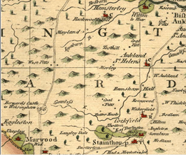
1770: Kitchin’s map
It shows 2 sites for coal pits:
- to the east of Toft Hill. This could refer to the pits at Greenfield under the ownership of Sir John Eden.
- to the north of the River Gaunless, near to Butterknowle, to the north of Cockfield and Evenwood. Perhaps this referred to what we would now know as Norwood Colliery.

Above: A detail from Kitchin’s map
The 1765 Allotment Pan [12]
Carterthorne Colliery was not shown. There was a land holding by the Peirse family – a plot of land measuring about 11 acres owned by Rachael Peirse,[13] located to the north of the Red House, Etherley.
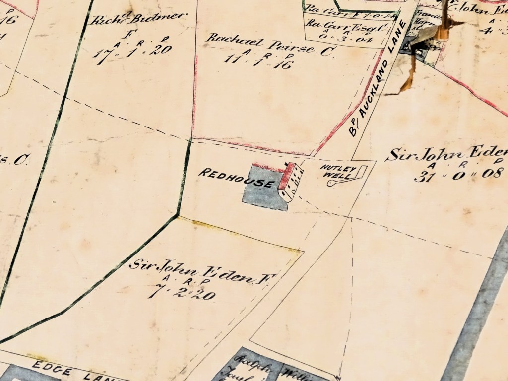
Above: A detail from the 1765 Allotment Plan to show Rachael Peirse’s land
1769 Plan for Mr. Rachael Peirse [14]
Carterthorne Colliery was not shown. In 1769, Richardson prepared another plan, specifically for Rachael Peirse. A note explains:
“This Plan was drawn by the order of Mrs Rachael Peirse for the use of her son Richd. Peirse Esq by Her most obedient servant Richard Richardson, one of the Commissioners and the Surveyors in the Division June 20th 1769.”
As well as the area near Red House, this plan shows land between Mr. Sanderson’s land to the east and William Morley’s land to the west, north east of the modern day Toft Hill Hall, described as, “Mrs. Rachel Peirse Ground”.

Above: A detail to show Mrs. Peirse’s land
1777 Bowen’s map
This map shows coal pits in the same areas as the earlier Kitchin’s map. Of the 2 locations, the one to the north of the River Gaunless is within Railey Fell.
Above: A detail of Bowen’s map
Known locations of Carterthorne Colliery
There are 2 pits which bear the name Carterthorne Colliery but these, at first glance, both can be discounted as the site of the original 1714 pit. Both were development much later. They are:
1. To the west of the modern-day A68 road, opposite the junction with Sloshes Lane. It is believed that this pit was developed by the Chaytor family of Witton Castle. It is likely that Henry Chaytor developed this colliery between 1857 and 1898.[15] The copy of the Richardson map prepared for Mrs. Rachael Peirse in 1769, has a note:
“Mr. Chaytor’s proposed line of railway.”
The route ran from the north east into Mr. Cuthbert’s land were, “Screens here” is noted and marks indicate the possible site of a colliery on Mrs. Peirse’ land to the south. The date of these notes is unknown but must be after 1816 because the Chaytor family did not own Witton Castle until then.

Above: Plan showing the proposed route of Mr. Chaytor’s railway.
The actual route of a tramway was located further south, outside the boundary of Witton Castle grounds, to the south of Sloshes Lane and travelled eastwards into a stock yard, north of modern day Phoenix Row. From there, coal presumably was transported to Phoenix Pit, Etherley Colliery, Old Etherley Colliery or the Iron Works at Witton Park.

Above: A detail from the 1924 OS sheet which shows the site of the disused Carterthorne Colliery and tramway which ran eastwards.
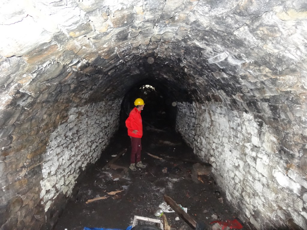
Above: The tramway tunnel under Sloshes Lane photographed in 2021.
2. To the south of High Toft Hill Farm and developed by Andrew Mein (1831-1905) and his son Henry J. Mein (1854-1920) in the late 1890s.

Above: Plan to show Mein’s Carterthorne Colliery
The location of the “1714 Carterthorne Colliery” remains unknown. However, given that the scale of the workings was likely to be relatively small scale and the amount of waste would have been limited and it can be argued that regeneration of the site may have obliterated surface features by the time the site was surveyed in 1857. On reflection, perhaps the historic site of Carterthorne Colliery, is the one opposite Sloshes Lane – perhaps this site is the most likely to be the most ancient and the original site. This is a highly speculative suggestion.
ACKNOWLEDGEMENT
Thanks to Mrs. Anthea Tallentire who loaned us the documents and allowed ED&RHS to copy and post on the website.
REFERENCES
[1] Sometimes spelt Raley Fell.
[2] The term, “The Viewer” was in common use during the 1800s to describe what we would call, the Colliery Manager and was the precursor to the mining engineer.
[3] Thomas Peirse’s daughter Anne married a Richard Hodson from Witton-le-Wear – were Richard and John related?
[4] The DCC Record Office may hold burial details for the church of St Philip and St. James, Witton-le-Wear which could be researched.
[5] “Pedigree of Peirse of Bedale and Thimbleby” from “Pedigrees of the County Families of Yorkshire Vol.III North and East Riding” 1874 Joseph Foster. Note – there are 3 men named Thomas Peirse and there is debate as to the actual person (which Thomas Peirse?) who inherited the wealth of the Hustler family from the unmarried Evereld Hustler.
[6] “Thomas Hustler Esq. 1738/39-1802” 2020 Stephen Bird.
[7] Possibly Linburn in which case the nearest pits would be West Pits, Woodland probably Crake Scar Colliery.
[8] Probably now known as Norton Fine Beck
[9] Word cannot be deciphered
[10] A plan of the Division of a certain Moor or Common called by the name of Railey Fell within the Manor of Evenwood and Chapelry of St. Helen’s Auckland and County Durham shewing the Allotments belonging to the Townships of Evenwood and West Auckland by Richard Richardson of Darlington 1765.
[11] “Parliamentary Surveys of the Bishopric of Durham” Surtees Society Vols. 183 & 185, 1971-72. pp122-23 & 183.
[12] A plan of the Division of a certain Moor or Common called or known by the name of Railey Fell within the Manor of Evenwood and Chapelry of St. Helen’s Auckland and County of Durham, shewing the Allotments belonging to the Townships of Evenwood and West Auckland by Richard Richardson of Darlington 1765.
[13] Rachael was the wife of Richard Peirse, mentioned in the 1712 lease. She died in 1771.
[14] A plan of the allotments in the Division of Evenwood and West Auckland Commons being part of a large moor called Railey Fell in the Chapelry of St. Helen Auckland in County of Durham as divided by an Act of Parliament in 1762.
[15] The Chaytor family did not live in the area until after 1816 when William bought Witton Castle. He was associated with coal mining at Witton Park and the S &DR Company. His son Henry re-purchased the Witton Castle estate in 1851 (source https://wittoncastlecountrypark.co.uk/estate-history/). Information on the first 3 editions of the OS maps clearly show that these collieries were not sunk until later.
